Vinland Blog 2026
Introduction
I have always been interested in the Vikings, especially their visits to North America and the encounters with the natives (Skraelings). As if to spur this on, I was commissioned to build a model of a Viking Longship for our Local Scandinavian Cultural Center. Near the same time I obtained a copy of the book Westviking by Farley Mowat (1965) and after reading it, decided to take a vacation to Newfoundland where L' Anse Aux Meadows, the only verified Norse site in North America is located. What I learned in Newfoundland and the subsequent results of my research is remarkable.
|
Probability Factor
PF1. Not likely. Prove to me that it is.
|
|
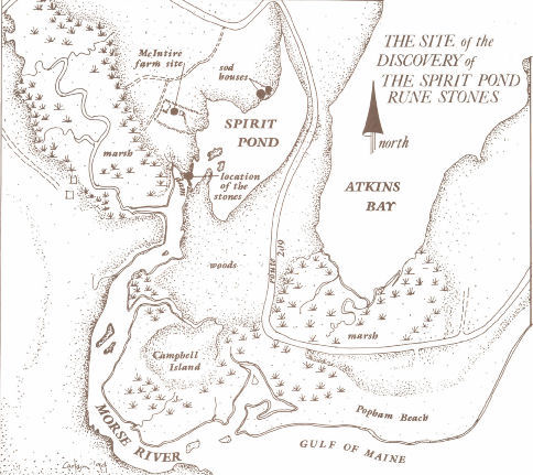
| A detailed map of the Spirit Pond area showing longhouse and tablet find locations. (NEARA) |
|
| The Kingittorsuaq runestone dated 1314 (Previously published on blog) |
|
| The obverse of the Spirit Pond Amulet showing a cross. (Photo Vesterheim Norwegian-American Museum, Decorah, Iowa) |
|
| The reverse of the Spirit Pond amulet. (Photo Vesterheim Norwegian-American Museum, Decorah, Iowa) |
|
| The minor tablet found at Spirit Pond (Photo Scott Wolter ©2009) |
|
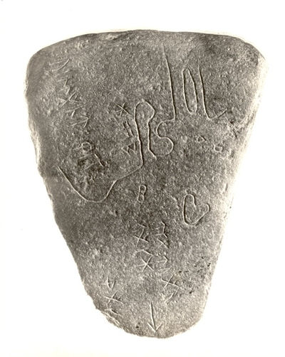
| The Spirit Pond map stone. (Photo- NEARA) |
|
| Drawing of the Spirit Pond map stone. |
|
| The reverse of the Spirit Pond map stone (Wolter) |
|
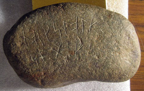
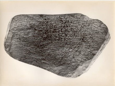
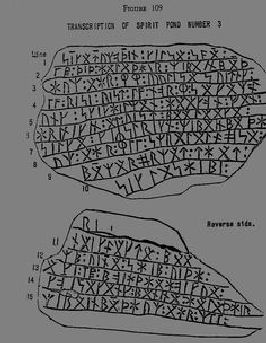
| The Spirit Pond runestone (Photo- NEARA) |
|
| Drawing of the Spirit Pond Runestone |
|
| Seventeen presage their doom |
|
| Current map of Spirit Pond with the Map Stone drawing superimposed. |
|
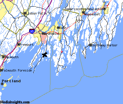
| A basic map of the Maine/New England coast. An X marks Spirit Pond |
|
| The Svingerud Stone, discovered in a cremation dated btween CE1 and 250 sets back Elder Futhark to at least BCE 200 |
|
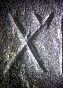
| Fourteenth century Hooked X rune |
|
| Pendatic dating from the Larsen Manuscript |
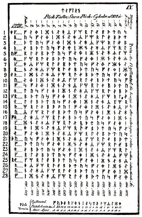
|
| The Easter Table from a pre 1838 manuscript |
|
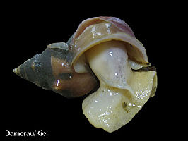
| No escargot here. Just a sea snail |
|
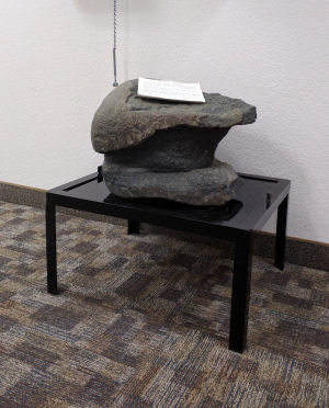
| An example of an anchor stone. This is a reprint of the anchor stone at Kensington from our December 2019 blog |
|
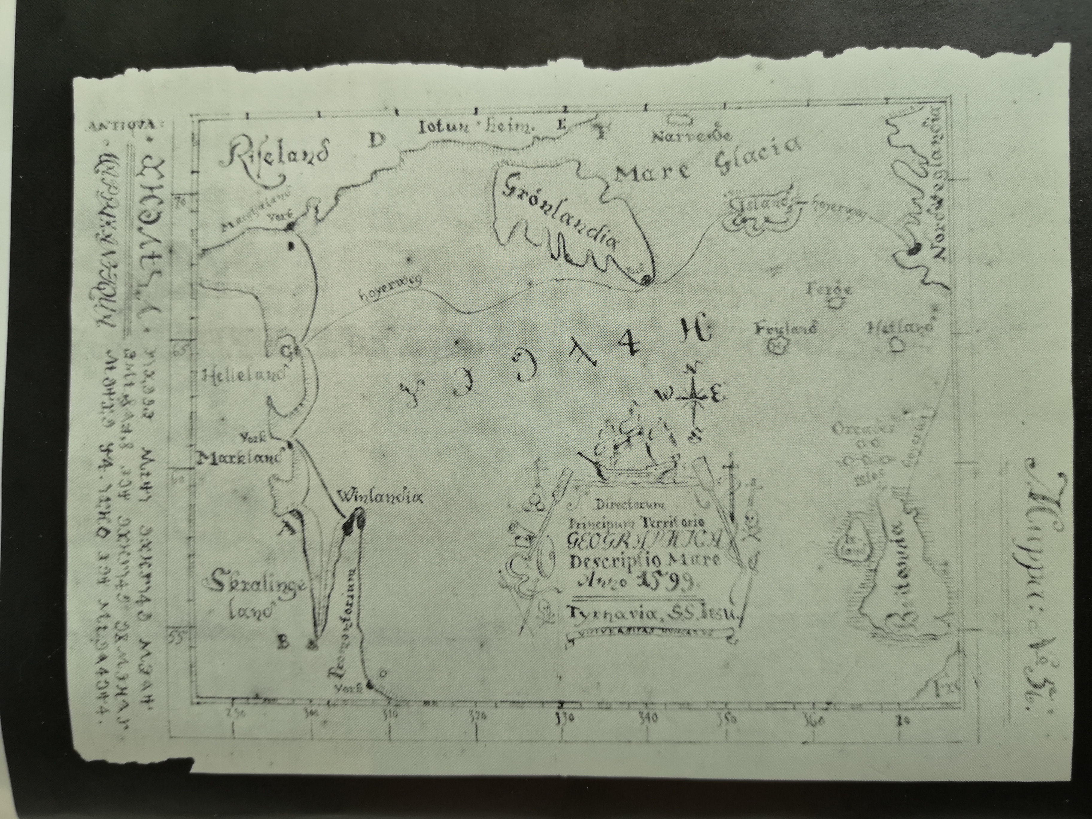
| TEASER. This will be coming up in a future blog. This is the Bishop's Map of CE 1599 detailing the visit of Bishop Jon to Vinland in CE 1120. It was obtained from a Hungarian monastery by Helge Ingstad in the late 1950s during his search for a Viking settlement in Newfoundland |
|
| This book available through the Maine Historical Society details the Goddard Archaeological site |
|
| The type of coin found in 1957 (photo credit ancient origins) |
|
| A close up of the Maine Penny (photo credit ancient origins) |
|
| An example of burins |
|
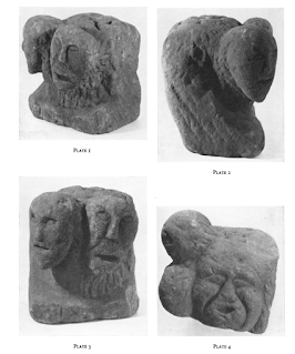
| An example of a Celtic Tricephalos |
|
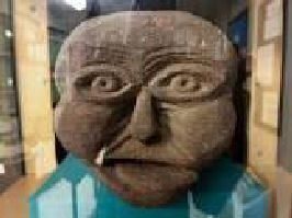
| One of the three faces on the D'Arcy Tricephalos |
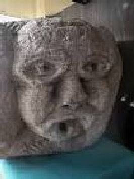
|
| One of the three faces on the D'Arcy Tricephalos |
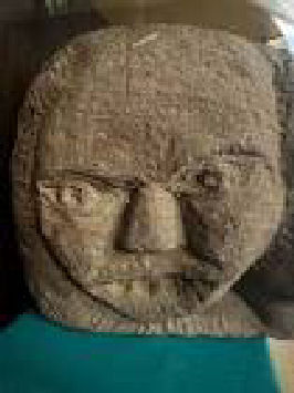
|
| One of the three faces on the D'Arcy Tricephalos |
|
| The cavity at top meant for votive offerings on the D'Arcy Tricephalos |
|
| A replica of the Ramsund Carving in Lunenburg, Nova Scotia |
Archive 2018 *** Archive 2022
Archive 2019 *** Archive 2023
Archive 2020 *** Archive 2024
Archive 2025
Back to home page
January 15
Welcome to 2026 and another year of the Vinland Blog. Before we get started I am pleased to announce the digital release of Twenty Five Doors today, a compedium of short stories and poems. Please e mail me if you would like a copy. Additionally, the SECOND EDITION of Kjalarnes Found is now available on AMAZON. Be sure to specify Second Edition when looking it up as the First Edition is now out of print.
Now, an interesting tidbit that just came out, then on to a very significant feature:
******
Wood analysis of the Gardar Cathedral in Greenland (CE 1000-1350) has resulted in 26 separate fragments from North America. Experts conclude this is an indicator of 'sustained activity' with the New World. More detailed analysis is stating 350 years!
******
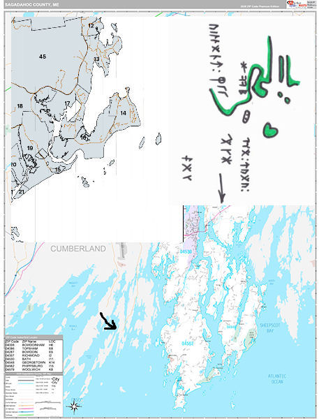
Phillipsburg, Maine
Mooring Stone
Longhouse Foundation
Amulet 1971
Tablet 1971
Runestone - Map Stone 1971
Runestone - Inscription Stone 1971
In 1971 a discovery was made by Walter Elliot, a carpenter, searching for arrowheads at the south end of Spirit Pond where it meets the Morse River. It consisted of three carved stone tablets and an amulet. This (like usual) immediately begat claims of forgery, mainly because of the confusion of what was written on the inscription stone, which subsequently became known as the Spirit Pond Runestone.
A major detractor and so called expert whose name is not worth mentioning quickly quacked 'Hoax' because he did not understand what they were, claiming they were not eleventh century runes. Of course not, they are fourteenth or early fifteenth century. The runes have since been deciphered by knowledgeable linguists.
Unfortunately Walter Elliot passed away before the runes could be interpreted. Sadly, on his deathbed his last words were, "I just wanted to know what they said."
The runes on all these finds closely match those of the Kingittorsuaq runestone of Greenland (GR1) found in 1823. This story from the far north is dated 1314 in pendatic dating and is the same type of numbering as the date (1362) on the Kensington Runestone. The Narragansett stone also uses this evolved runic language.
+++
Mooring stone
Later searches of this area by Scott Wolter turned up a mooring stone.
PF 5
+++
Longhouse Foundations
The longhouse foundations were discovered by the New England Archaeological Research Association (NEARA). They were several hundred yards north of the 'hole stone' and made of sod with wooden floorboards. The bottom boards were carbon dated to 1405 +-40 with others showing habitation into the 1600s.
PF 5
+++
We now come to the items found in 1971. These were found several hundred yards south of the longhouse and about twenty five yards from the mooring stone. See the map.
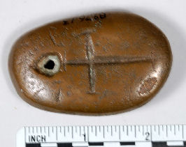
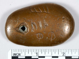
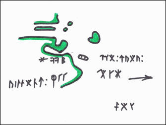
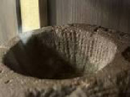
Stone Amulet
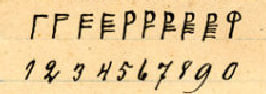
This 2" x 3" oval Basalt stone amulet, holed at the top, features a Templar(?) Cross on one side; pendatic dating(20), VIN in Younger Futhark and what appears to be an Ogam symbol on the other. I am guessing twenty as well. I was fortunate to examine the museum copy at the Vesterheim Museum in Iowa which was identically reproduced from the original. The wear on the hole in the stone indicates it was worn for some time. (Take a look back at the Seneca Ladd Collection photo I posted last year.)
PF 5
+++
Tablet
This is also known as the Folk Stone. It is comprised of two rows of twelve symbols. Most are of Younger Futhark but also includes a Hooked X and a bind rune. It translates out to NORKSLOLK SPAEK. We will come back to this later. Most experts agree this tablet was used for testing carving purposes.
PF 5
February 15
Breaking news: A child's thigh bone fragment found along the coast of Labrador has been DNA tested and is NORSE! The Governments of Canada and Iceland plan to work together to mount an expedition to examine others sites along the coastline. Mallery identified fourteen sites along the coast of Labrador in 1946. After fifteen years of this blog it is pleasing to see the results turning up that I predicted years ago. Now to continue with the findings at Spirit Pond.
+++
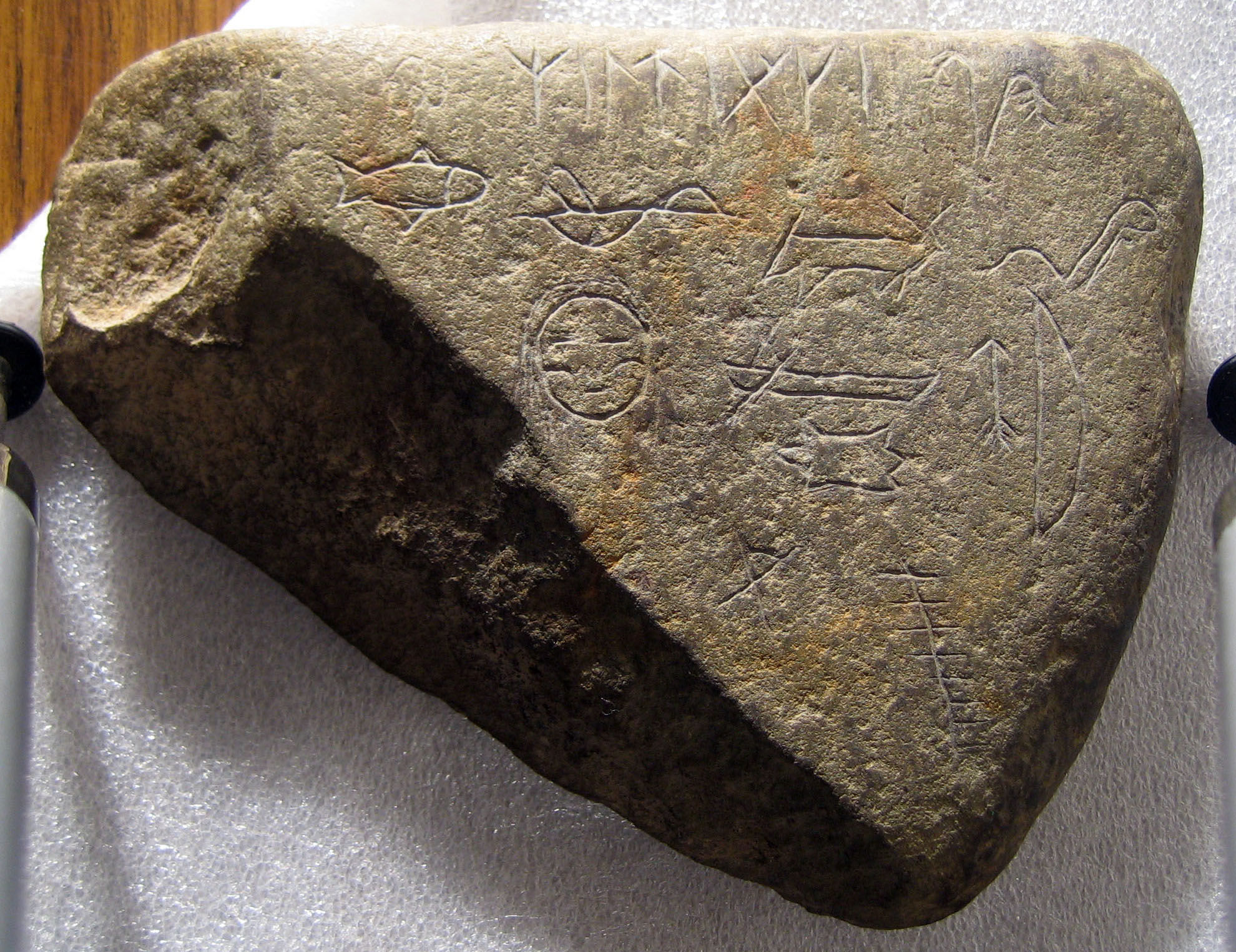
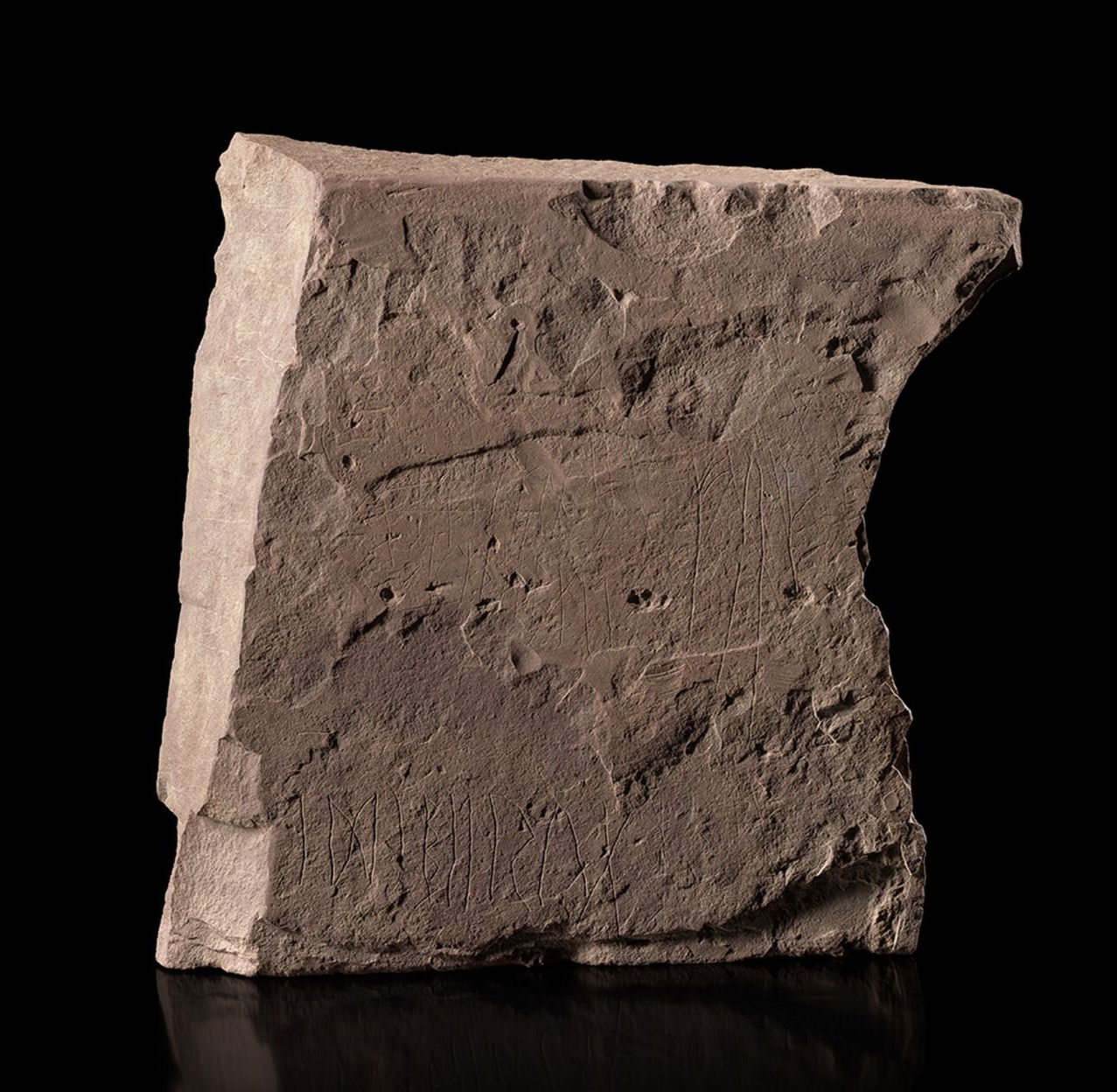
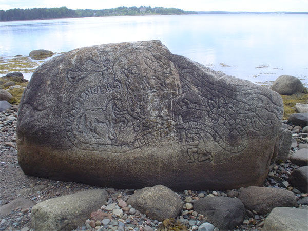
The Map Stone
Known as the Map Stone this features a coastline with lettering and pendatic numerals. It contains the hooked X and secret Easter Table dating of 1402.Most experts agree that Norse maps of this age will generally have east at the top. The inscriptions seem to agree by generally following this direction but in this case an arrow points southwest to 'Vin'. Newport is approximately 50 miles away as the ship sails.
Vinland takes 2 days
When this triangular tablet is placed upright with the apex downward the map closely resembles the area of Spirit Pond. There is a fish hook shape to the land and the islands below are comparable up to and including (what to them was) heart shaped Seguin Island Light Station. There is an X on the map where the longhouse foundations were discovered. Remember that early map making will have distorted shorelines not only due to visual inconsistencies but we also cannot dismiss changes in topography over the centuries. This one is crude and hand drawn and the very first map to display the coastline of North America.
Numerous Younger Futhark runes are scattered across the map including the pendatic date 21.
The other side of the stone is rife with carved figures. At the top is the Younger Futhark runic inscription with a hooked X and bind rune that says something like RIMLAEKI. (Wolter suggests 'good land' in Algonquin but the word 'lake' also has Norse roots. (Loan words?) At the bottom is something in Ogam. Some experts suggest this is a 44, again confirming latitude.
Between this is a number of symbols of a very native appearance. Reading from top left is: fish, water bird, deer, snake; second row: shaman face, man paddling canoe over pelt, bow and arrow; at bottom left a final symbol appears to be an upside down tipi similar to the one on the New England Mystery Stone that we covered in our July 2025 blog entry. It could also be a crude attempt at the Ogam letter Iphin. Regardless, these mystery native symbols may lead to something further. Wolter's opinion is that these were carved as indicators of what was in the area. Let's look at another possibility. Perhaps these symbols are an Algonquin pictograph language in writing. Look at the photo of the Seneca Ladd collection in July of last year's blog after the mystery stone. There are numerous symbols inscribed on stone amulets similar to the ones above. The Bourne Stone and the Judacilla Rock are but a few that contain similar pictographs. Also, the more one googles it the more this is feasible. Take a look at this link:
But that is something for someone else in the future to research. I am searching for Viking or Viking related stuff.
The below link is a more detailed analysis of the Map Stone. What the author describes as far as the secret writing on the tablets say; I must admit that after fifteen years of searching for the Vikings, I find his conclusions to be a little extreme. Mind you, at one time I would have never believed the Norse to be in Oklahoma or the Beaufort Sea either. Time, technology and further research will tell if his translations are correct. We must keep an open mind.
PF 5
+++
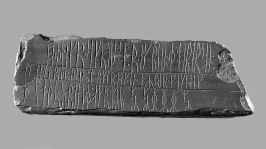
The Inscription Stone
Now we come to the most baffling of the stones. This contains 16 lines of runes on two sides, the hooked X as well as barred runes comparable to those of the Ukna slab (Sweden 1325). It contains the pendatic numerals 44 which measures closely to 44 degrees latitude, the location where it was found. It has Easter Table dating to 1401.
There are conflicting translations about what these runes say and you can view some on the following links, but I believe the translation by Robert Johnson and Janey Westin in The Last Kings of Norse America to be the most accurate, as we will see. (Remember, when a correct research path is followed it will always result in further revelations.) I would recommend this book, for the authors' viewpoints are critical in finding the correct history of Pre Columbus North America (PCE). Another book important to our studies here is The Hooked X by Scott Wolter.
Here are a couple other varying opinions:
Noahs Age Numerologist Viewpoint
Spirit Pond Runestone translation
Here is the translation by Johnson/Westin. I have put in the punctuation which will help us to make sense of it. This is a sample of a typical, Norse style epic poem:
Fallen kinsman, ever valiant fellows,
A roaring sea struck seventeen dead,
Hail to you, weeping fountains.
Year 20 we lost the company of twelve companions.
12 daghrise westward, 10 daghrise northward,
The saga of a young Folkung,
Bearded chief man Haakon discovered a circle by being able to sail towards the west on the lakes of the trade empire.
Weeping fountains,
Year 21.
A shout into the burning lights! Blessed Maria. Alas!
Powerless those on the Seal Ship to proceed to obtain an edge to devote attention in regard to win the ship against the terrible storm,
Seventeen presage their inevitable battle stroke,
accept the sinking,
the bane of their approaching death,
Hail to you weeping fountains. Year 21.
Abbreviations on this stone are similar to those on the KRS.There are bind runes, bars, dotted Rs and the hooked X present.
March 15
So what does this all mean?
To provide the answer we must work back and forth with some of the research we have already gleaned. It is important to consider how the SPR Spirit Pond Runestone is related to the KRS Kensington Runestone.
Based on everything we have learned about Norse America so far, using Johnson/Westin's theories and translation, Hjalmar Holand's earlier suppositions as well as Scott Wolter's work, this is along the line of what I believe happened:
We step back to 1354 when Paul Knudsen was given a letter of marque to search for the missing Greenlanders of Ivar Bardarson's earlier report. Whether this expedition actually took place is unknown but it is an indication of intent. So we know that the Knorr was to be sent out on a tax gathering mission labeled as good religious missionary work. But what else went with it?
Several different sources lead to the conclusion that a Royal Expedition took place from 1361 to 1364. The soon to be King Haakon VII made a tour of his future realm. Although his exact birth date is unknown, the poem on the stone gives us his age when he took the tour.
Thus, we assign the 'year 20' to 1362 and the 'year 21' to 1363.
From a separate historical source we learn of the cleric Nicholas of Lynn who in that same time period was in a voyage that took him north to the Arctic Circle and his discovery of Magnetic North.
Bishop Olaus Magnus reports in 1505 in the Historia De Gentibis Septentrionalibus that two skin boats were captured when they attacked the ROYAL FLEET in Greenland while they were on their way to Vinland. These kayaks are apparently somewhere in a church in Norway according to Holand. Another source tells us the Norwegian Kingdom was so large it took tax collectors 3 years to cover it's entire expanse.
It is most likely the ships of the Royal Expedition made a tour of the North Atlantic Viks where Haakon learned of the Ginnungagap (the Hudson Strait) and the great inland sea (Hudson Bay). These are detailed on the 'Bishop's Map' which will be looked at in detail later. They then proceeded to New Vinland and it's capitol of Norumbega.
At Norumbega, while Haakon toured New Vinland, an expedition of thirty men were sent west 'over the lakes of the trade empire' where we know they met disaster with the massacre of ten men near Kensington in 1362.
Two ships were sent back north through the Ginnungagap (the Hudson Strait) to the 'haven' in Hudson Bay. One ship with ten men (let's call it the Knorr)was ordered to remain there to wait in a prearraged agreement with the Kensington Expedition while the other ship (the Seal Ship) took Nicholas of Lynn north for his explorations.
In 1363 Haakon returned to Norway where, now of legal age, he married and became King.
Meanwhile, the Kensington Expedition made it to the Haven in Hudson Bay, where upon their returning to Norumbega in 1363, the Knorr was sunk in a storm. This was most likely in the fall when Canadian storms can whip up very quickly.
In 1364 Haakon was crowned and 8 men (one of who was Nicholas of Lynn) returned to Bergen to confirm their voyage. Whether the missionaries or tax collectors were successful in their part of the mission is unknown, but by their return they had 'completed a circle' and made a huge land claim for the Norwegian Kingdom, north eastern Canada.
Editors note: The cans of worms keep coming. Does this now mean Norway has territorial claims over Labrador, Quebec and Northeastern Ontario similar to claims that Beothuk remains belong to their descendants in Iceland?
Numbers
This adds up.
30 men (22 Norwegians and 8 Goths) went west over the Great Lakes after having learned of the Graeneveldi. It would not make sense for them to go without guides and I suspect the 'Goths' are actually inhabitants of New Vinland who have been to Kensington and the haven in Hudson Bay.
Editors comment: Sigh. Another can of worms opened. If the 'Goths' are inhabitants of the area, does this mean it was settled by Danes from Gotland? But then, what about Norumbega (New Norway)?
10 more men went by ship through the Hudson Strait to a harbor somewhere in Hudson Bay.
In 1362 there were 10 men massacred near Kensington. That 2 extra were lost is not unfeasible. Wild North America is a dangerous country. That puts expedition members down to 28 in total including the ones at the haven.
In 1363 the sinking of the Knorr marks the loss of 17 men, leaving 11. If 4 happened to be Norumbegians (Goths) that stayed behind when they got back to New Vinland, 7 came to Bergen.
The report says 8 came back. But it also says 2 were priests. If 1 of these was Nicholas of Lynn, that left 7, one of which was also a priest.
According to codists, a secret message on the Kensington Runestone says 'Ivar carved me'. It would be very likely a priest would have the literacy to carve the saga on the stone, perhaps even the very same Ivar Bardarson who reported the missing Greenlanders in 1342.
The Sinclair Expedition and Who Dunnit
I am not going to go into a great number of details here. Scott Wolter does a very adequate job of that and this is more related to Templars rather than Vikings, although we do see connections.
The Sinclair Expedition took place from 1398 to 1402. There is strong evidence that Henry Sinclair built the Newport Tower.
Johnson/Westin believe the Spirit Pond Inscription Stone is a commemorative poem made to celebrate the Royal Expedition of 1361-1364. With the dating of 1401, it ties in very well with Sinclair but I do not believe it was carved by anyone from his group. This was done by a resident of New Vinland.
The nature of the wording on the back of the Map Stone indicates someone rather knowledgeable in Runic Norse but also Ogam (Alban-Celt) and Native Algonquin Petroglyphica. Yet the numerous scratches and marks as well as the folk stone NORKSLOLK SPAEK (Norsk Folk Speak) being mis-spelt (we call them typos) indicate our fellow was not the best at carving. The Folk Stone, probably the title of his poem, suggests he counted himself as Norsk. He may have even personally witnessed the Royal Visit him or herself. Perhaps he was on it. His ethnic background may have been a blend of the three cultures in the region. Could he have been a cleric? We also have longhouse foundations that indicate regular settlement from 1400 into the 1600s.
The Metis society is a prime example of how a unique culture can evolve within short generations. We can also refer back to Peter Kalm's description of French Canadian inhabitants in 1750 for additional comparison.
Based on the wear, the amulet stone was kept for a long time and eventually discarded with the tablets, reasons unknown.
Although the Sinclair visit is more closely related to the Templars according to Wolter, we must also be aware of it's Norse connections with the mutual sharing of the Hooked X rune and its associations. We see it on an astrolabe at the Oxford Museum, in the sigla of Columbus (who was related to Henry Sinclair) and as a Templar's symbol for Knights of Christ.
The stones are currently in the Maine State Museum while Spirit Pond is preserved as a nature site.
Geographical location: 43.747,-69.811
PF 5
******
April 15
Heard from an ancient Pagan priest: "We feed the Gods with sacrifice and entertain them with rituals".
******
Sheepscott, Maine
Snail Shells 1950
Digging in New England has come up with European North Sea snail shells that date to the 11th century. These had to have been transported here by ships. Reported in 1950 by Brondsted.
Geographical location: 44.049,-69.616
PF 3
******
Bristol, Maine
Anchor Stones
These were found in Pemaquid harbor. They would be similar to the one found at Kensington. (See the photographs in our archives- December 2019)
Geographical location: 43.892,-69.534
PF 3
******
Monhegan, Maine
Cairn 1997
Also known as Manana Island, Fell reported these earlier discoveries in 1997.
Near the cairn a copper spearhead or bronze knife (according to Fell) was found. Ed note: Perhaps both. There is also an Ogam or Runic inscription on a ledge that states: ENHYNS LNNLTHNILNY
No further information is available at this time.
Geographical location: 43.767,-69.397
PF 3
******
Searsmont, Maine
Celtic Face 1982
Fell reported this carved face in bedrock.
Geographical location: 44.366,-69.353
PF 3
******
Deer Isle, Maine
Ogam Inscription
In Penobscott Bay, Deer Isle is the host of a rather interesting Ogam inscription that reads:A sheltered island where ships may lie in harbor. Haakon brought his cog here.
Geographical location: 44.243,-68.700
PF 3
******
May 15
******
Brooklin, Maine
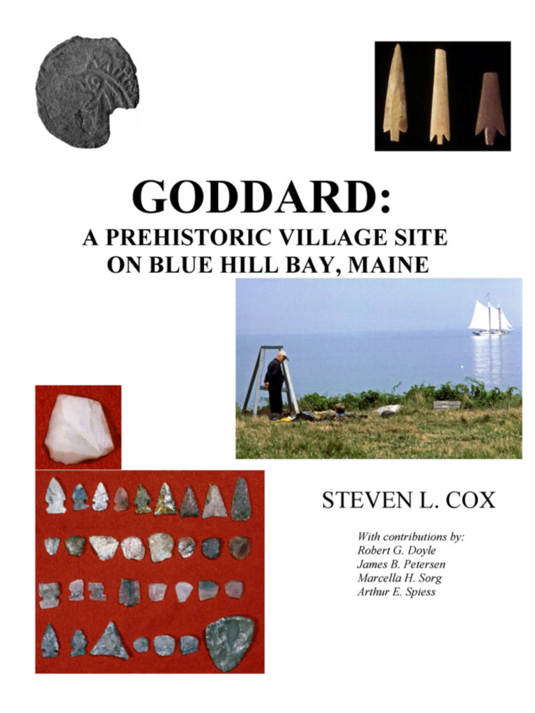
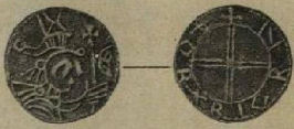
Coin 1957
Burin
Local resident Guy Mellgren found this silver coin, now known as 'The Maine Penny' while searching through the Goddard Archaeological Site at Naskeag Point on Penobscot Bay. This site has turned up over 30,000 indigenous artifacts and has been dated as being occupied between CE 1180 and 1235.
The coin, originally thought to be British, was identified as belonging to Norwegian king Olaf III Kyre who ruled from 1067-1093 (Sutherland states 1065-1080). It is in very worn condition and had been holed at one time.
This coin has been accepted as a genuine find by credible authorities and is used as an example in current educational programs to indicate the extensivity of the native North American trade networks.
As a side note Olaf II 995-1030 is purported to have visited Vinland 5 years before his death in 1025 where he was so impressed with the sight of a bison he commissioned one to be carved as the figurehead for his ship. However, if this story is true, I believe it was more than likely Olaf III, which corresponds more correctly with our coin.
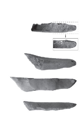
Also found at the site was a rama chert artifact from northern Labrador and Dorset burins from even farther north. Burins are essentially stone drills.
Here is the Wikpedia link to the Goddard Site. Through it are more links to the coin. Again, I urge caution when using Wikpedia regarding Norse America. They are rife with misinformation as they use many sources which have been proved antiquated and unreliable.
(Editors note: Sigh, more work. Someday I will have to educate them and fix their errors.)
Geographical location: 44.266,-68.734
PF 5
******
Overton, Nova Scotia
Runestone
This is known as the Bay View Stone. No further information is available at this time.
Geographical location: 43.844,-66.150
PF 3
*******
Washington County, Maine
Spearhead and pendant (bronze?)
These were found along the Penobscot River. No further information is available at this time.
Geographical location: 44.999,-68.617
PF 3
******
June 15
*******
I TOLD YOU SO
A new technology led by one Dr. Goodman has just verified Norse presence in Minnesota! The science is called Metagenomic Lake Sequencing. By taking mud core samples from oxbow lakes and testing the samples from the Medieval Warm Period CE 900-1250, they can determine what living creatures and plants were present during that time. Haplogroup H1 DNA fragments (Scandinavian) at a rate of .05% were discovered.
Initially one might think .05% is insignificant but considering the vastness of North America with the multitude of species, it is really a blockbuster.
As an aside note, .05% is enough alcohol in your system to have your liscence suspended.
******
Update on the D'Arcy Stone Head
I can now add further information on this mystery stone discovered in 1931 in the middle of a gravel pit near D'Arcy, Saskatchewan thanks to my recent research from a book called 'Celtic Pagan Britain'.
This item is called a tricephalos. They were common among the pagan Celts of Britain and Europe, being representative of a three faced god. The hollowed out area at the top was meant for votive offerings.
The mystery deepens. Is this Celtic? Were the North American Celts this far northwest? If so, what was it doing in the middle of a gravel pit? Is it pre Younger Dryas? Is it real? Someone in the future is going to have a lot of fun with this one.
******
Update on the Overton, Nova Scotia Runestone from last month:
This stone, first discovered somewhere between 1895 and 1898 is also known as the 'Bay View' stone. It is like the below Yarmouth stone with the first line almost identical. It was found within one kilometer across the harbor from it. It is also detailed in the Wikpedia article on the same. It's current location is unknown.
******
Yarmouth, Nova Scotia
Runestone 1812
This Quartzite stone was discovered by Richard Fletcher, a retired British army surgeon before 1812 and subsequently known as the Fletcher Stone. Initially claimed to be Norse runes, it has been examined by many experts. Ingstad stated the runes are definitely NOT Norse. The runes are similar to those on the Bat Creek stone. Many experts identify them as Celto-Iberic.
The following Wikpedia article covers this 400 pound stone quite nicely:
The stone is currently on view at the Yarmouth County Museum.
Geographical location: 43.837,-66.147
PF 3
******
Tusket River, Nova Scotia
Runestones 1880
First mentioned in a letter by T. B. Flint in 1880, the Tusket River Runestones were on an island at the mouth of the river and accessible by boat only. There were two stones with runes similar to the Yarmouth and Overton stones. Their current location is unknown. They too are mentioned in the above wikpedia article.
Geographical location: 43.837,-66.007
PF 3
July 15
******
As of today CROSS AND CONTRACT has been released digitally. This is a story taking place in Western Canada between 1866 and 1886. One man fights for his land, the other for his country.
Anyone wishing a complimentary digital copy may email me:kelwionz@gmail.com.
******
New Ross, Nova Scotia
Longhouse foundation
No further information is available at this time.
Geographical location: 44.737, -64.465
PF 3
******
Lunenburg, Nova Scotia
Runestone 2012
This is a prime illustration of what can be encountered. Not all is as it seems. This stone was carved recently by locals and is a replica of the Ramsund Carving in Scandinavia.
Geographical location: 44.361,-64.326
PF 1
******
Tors Bay, Nova Scotia
Axe 1880
"In 1880, an eleventh century Norse ax head, was found by a farmer plowing a field in Tors Bay, Nova Scotia. The ax was reported to be caked with mud, rust and much pitted. Having no idea what it could be useful for in the condition it was in, the farmer laid it on a shelf where it stayed until 1936. The farmer's granddaughter (known only as Mrs. Grover) would show the ax, in that year, to a prospector by the name of James P. Nolan. Curious about it, he asked if he could clean it in order to get a better look at its design. Mrs. Grover granted permission and Nolan took it to his shack where he put it to soak in kerosene for the purpose of cleaning it. While it was soaking, the shack caught fire and burned to the ground. As Nolan rummaged through the ruins, he located the ax and found that the mud and rust had been loosened by the fire. On the broad face of the ax, he discovered strange markings that he did not understand. It was later examined by Alden B. Greninger, Professor of Metallurgy at Harvard University, who in his concluded investigation statements of the ax, wrote: The ax is undoubtedly of primitive structure; the actual metallographic structure of the ax metal is about the only one it could be if the ax were about a thousand years old. Despite the age, and the possible runic inscription, the ax is still privately owned and no further research has been conducted."
According to Fell, who examined it in 1982, there are tinfinaa markings on it.
The axe was known to be in the Goodwin collection, Cole Harbor, Nova Scotia but it's current location is unknown, however it may be the one listed at the Cole Harbour Heritage Farm Museum.
Geographical location: 45.198,-61.375
PF 3
....to be continued.