Vinland Blog 2021
Introduction
I have always been interested in the Vikings, especially their visits to North America and the encounters with the natives (Skraelings). As if to spur this on, I was commissioned to build a model of a Viking Longship for our Local Scandinavian Cultural Center. Near the same time I obtained a copy of the book Westviking by Farley Mowat (1965) and after reading it, Peg and I decided to take a vacation to Newfoundland where we would visit L Anse Aux Meadows, the only verified Norse site in North America. What we found there and the subsequent results of my research is remarkable.
Archive 2011-2017
Archive 2018
Archive 2019
Archive 2020
|
Probability Factor
PF1. Not likely. Prove to me that it is.
|
|
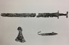
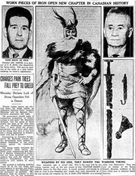
| The Beardmore relics |
|
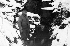
| 'Eddy' Dodd (left) with prospecting partner Fletcher Gill |
|
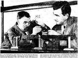
| ROM officials examining the artifacts |
|
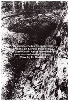
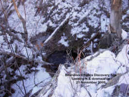
| The discovery site then... |
|
|
...and now. (Photo by E. J. Lavoie) |
|
| 1930s newspaper article |
|
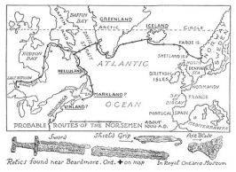
| Probable Routes of the Norsemen; Jefferys, Charles W. 1942 The Picture Gallery of Canadian History Volume 1, p.61 |
|
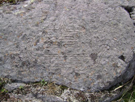
| Copper Harbor ship pictogram |
|
| Raven and Odin's Cross pictograms |
|
| Ship under plexiglass |
|
| Bear pictogram |
|
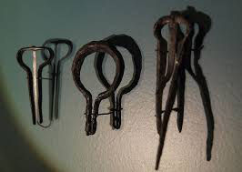
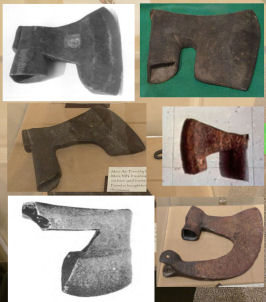
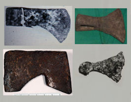
| Colonial Trade Axes |
|
| More early trade axes (Photo:Here Was Vinland - Curran) |
|
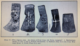
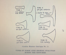
| Viking Axes (Illus: The British Museum) |
|
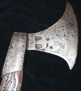
| The 1920 Mora Axe (Photo: O. Allman) |
|
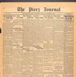
| The Piers Journal, Morrison County, Minnesota from November 1920 |
|
| Close up of article - top |
|
| Close up of article - bottom |
|
| Drawing of the Cambridge halberd (Here Was Vinland - Curran) |
|
| J. E. Dodd Affidavit |
|
| J. E. Dodd Affidavit Part 2 |
|
| James Watson Curran |
|
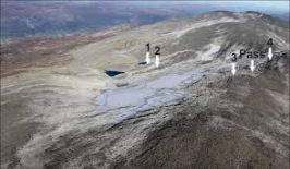
| Image of the Lendbreen Pass area, Norway (Smithsonian Magazine) |
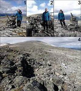
|
| Numbered areas above (Smithsonian Magazine) |
|
| Traverse City Runestone |
|
| A sixteenth century Norwegian battle axe (Photo - The Norwegian Battle Axe) |
|
| Batchawana Bay Axe (Curran) |
|
| Google satellite image at Traverse Bay |
|
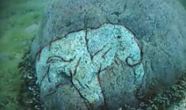
| Underwater mammoth carving at Traverse Bay |
|
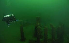
| Underwater stone structures at Traverse Bay (History Radar) |
|
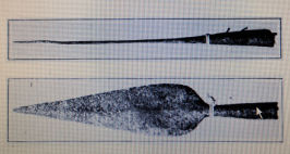
| Gros Cap Spearpoint (Curran) |
|
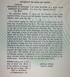
| Affidavit of the two teens who found the Gros Cap Spearpoint |
|
| The Portlock copper spud (Curran) |
|
| Comparison of Batchawana Bay axe with Hudson Bay Company Axe (Curran) |
|
| An interesting Soapstone carving in the museum at Churchill, Manitoba (Gary) |
|
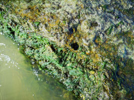
| The mooring stone at Berens River (Holand) |
|
| Sometimes adverse weather conditions.... |
|
| ....can make for a difficult viewing of a mooring stone |
|
| Choppy water and rocks do not mix well |
|
| Camp Morton mooring stone |
|
| Close up of hole |
|
| hole with algae wiped off |
|
| from the top |
|
| A selection of mouth harps |

|
| Einar Selvik of Wardrunna |
|
| Maria Franz of Heilung |
|
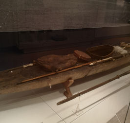
| Inuit harpoon and bladder at the Royal Ontario Museum |

|
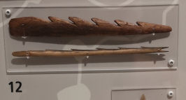
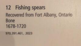
| Fishing spear tine.... |

|
| ...or muskrat spear? (both photos Royal Ontario Museum) |
|
| Bone fishing spear or harpoon point |
|
| Both photos Royal Ontario Museum |
|
| Map 1:Territory of the Graenaveldi |
|
| Map 2:Norse exploration routes |
|
|
Map 3:Mound Builders and Cliff Dwellers (Time-Life books 1992) Note: The dark blue dots are Mississippian Culture, synonymous with the time frame of the Vikings. |
|
| Battle axe comparison |
|
| Map 4:Military Artifacts |
|
| Map 5:Generic Artifacts |
|
| Some of the other axes in the Graenaveldi |
|
| Firestrikers in the Graenaveldi |
|
| A selection of various firestrikers |
|
| A firstriker from Novgorod |
|
| A three dimensional firstriker |
|
| Map 6: The Kensington Runestone and mooring stones |
January 15
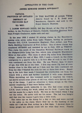
Beardmore, Ontario
Sword, Axe and Shield Rangel 1930-1931
Part 1
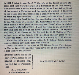
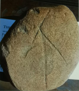
This is one of the more controversial of the Norse finds in North America. The items themselves are genuine but it is the nature of the discovery itself that is in dispute. The sword was dated to 850-1025 while the axe and rangel were 10th century.
In 1936 Jim (Eddy) Dodd sold the ROM (Royal Ontario Museum) these three items with the claim that he found them in 1930 or 1931 while prospecting south west of Beardmore, Ontario. He had found a large rock with a tree stump at its base bearing a quartz vein. When he blew the stump he found the artifacts in the schist (rubble). Dodd stated the sword was broken in removal. Thinking they were 'old indian artifacts' he set them aside where they remained for a number of years. He showed them to numerous people during this time and claimed later he would have sold them for the price of two packages of cigarettes. After 5 years sitting in his basement, where they were nearly thrown out by his wife, schoolteacher O. C. Elliot viewed and identified the artifacts as Norse. Dodd ended up selling these artifacts to the ROM. He initially asked $400 for them but was given $500. The museum had budgeted this amount for the purchase of some Norse artifacts, regardless of where they came from. The fact that they had a North American origin was just icing on the cake.
Detractors
Almost immediately claims that Dodd planted these items rose in dispute and they were withdrawn from display at the museum although the ROM initially defended the artifacts and the finding of them.
Dodd was accused of purchasing these items from a Norwegian immigrant in the 1920s and putting them aside for later 'discovery'. There has been much discussion about this both pros and cons with some unconfirmed sources pinpointing exact dates and persons.
A report stated that these artifacts were seen in Dodd's basement in the 1920s although addresses are confusing. One individual who supposedly said this was interviewed later and stated it was untrue. Also, as Dodd was a railroad employee he was required to have his name and address accurate in the telephone book and none of these claims can be verified including those of a former landlord who insisted the artifacts belonged to him. These claims were found to be baseless and it seems the landlord just wanted 'a piece of the action'.
As happened with the finder of the KRS, attacks on Dodd's character came into play. One strong bit of heresay circulated that Dodd created this hoax to 'show those museum guys'. In one brilliant piece of sarcasm it was stated that the Beardmore issue was finally solved when a drinking buddy of Dodd stated that he was 'known as a liar. Issue closed.'
Probably the most damning evidence came from Dodd's step son Walter who claimed in 1956 or 1957 that he was present when Dodd planted the artifacts and that he was afraid to speak up when he was younger. To counter this Dodd's wife, Walter's own mother stated that he disliked Dodd severely and made these claims simply to get back at Dodd.
In his book 'Westward to Vinland' Helge Ingstad stated that although genuine, he believed the Beardmore relics were planted but on the other hand Hjalmar Holand thought it was a proper find not related to the KRS as the artifacts were dated much older at 900-1100.
The Canadian Museum in Ottawa, where these artifacts are on display since the 1990s offers no comment at present as to their pedigree.
Here are somer impressive pictures. These are replicas of the artifacts given to the Nipigon Museum. They are identical to the originals:
February 15
Beardmore, Ontario
Sword, Axe and Shield rangel 1930-1931
Part 2
Prospector Jim Dodd claims:
Apart from finding the above items in the schist he discovered what appeared to be the impression of a wooden shield. On top of the shield was a 'shallow bowl of iron' which shattered to pieces when he touched it.
Dodd stated the 'Archaeology fellow' went to the site and found more items. He was told that plans were being made to protect it and possibly films would be made to document the location.
At one point, as a lot of the controversy on his find began, he was asked to sign an affidavit, which he initially refused citing he was not interested in receiving all this attention. This was eventually signed however.
Dodd's business partner Fletcher Gill claims to have found an artifact that he used as a pick until it was lost.
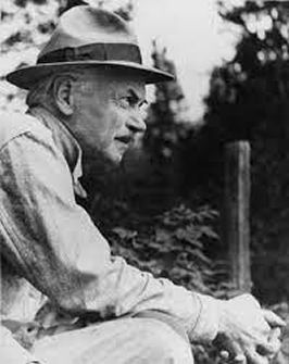
J.W. Curran, publisher of the Sault Ste. Marie Star, Judge Alexander McComber of Port Arthur and Dr. George E. Eakins of Port Arthur examined the site and made a report to the ROM.
Curran who claims to have seen the iron impression of the sword in the rock schist concluded the site was genuine and that Dodd could have possibly found a grave or abandonded campsite. There was no mention of bones by Dodd. If he did find bones, would he have even reported them?
The Fenwick Papers, donated in 1993 to the Nipigon Museum were published on the museum's blog in 2012. They give a precise account of this turbulently subjective matter on a day by day basis from 1937 to 1948.
Here are some good links:
Beardmore Relics - Hoax or History
With our modern day knowledge the fact that the Norse or Vikings explored parts of the lake and river systems of northern Ontario is not inconceivable. With a viable presence in Minnesota and trade centers in the north they would have been looking for a more convenient route to James and Hudson Bay rather than the Red and Churchill river systems. North America is a vast land.
This is certainly not a novel theory. Those who took Dodd's finds seriously were making suggestions within years of this event. There are articles by Dr. C. T. Currelly, Professor W. S. Wallace, and 0. C. Elliott in The Canadian Historical Review, March, 1939, and Sept., 1941, and "Here was Vinland," by James W. Curran, Sault Ste. Marie Daily Star, 1939.
As for the dating, it is important to keep in mind that Norse warriors would hand down their weapons from father to son and so the time frame of the sword for example may not neccesarily be when the event took place.
Did Dodd find these artifacts or did he plant them?
There was the report by Walter that he planted these items but no one ever witnessed them being found. The first we hear of them officially is in 1936 at the ROM after they have supposedly sat around for 5 years. There would have been no need of a 'planting'. Dodd's lack of knowledge yet perfect description of a shield boss is intriguing when iron bits are later found by credible witnesses.
All in all this site certainly needs further looking into.
The Canadian Museum should have the Beardmore site on file with complete documentation about it for a comprehensive examination in future.
PF4
Geographical location: 49.593,-87.964
March 15
Waukegan, Illinois
Drinking Horn
Reported by Anderson in 1994 this horn was found at a 30" depth in the ground and is apparently dated 1317. There is also a report of one found in 1951 along a roadside but this one was carbon dated to 1920. There is a strong Scandinavian presence in the area. No further information is available.
Geographical location: 42.371,-87.954
PF1-2
******
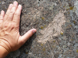
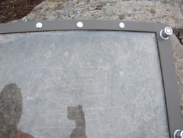
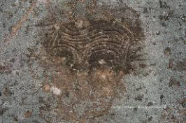
Copper Harbor Michigan
Ship Petroglyph
Mooring Stones
There are a large number of petroglyphs at this site but the most striking is that of a ship. Distinctly visible is the planking, square rigged sail with sewing details and the serpent prow and tail.Also at this site is petroglyphs of a cross within a circle and a raven. There is a curiously engraved bear present as well. All these figures hint of Norse interaction.
I could not find any good reports of credible age examination but the lichen growth in the photograph indicates some history and they all appear to be the same age.
This is an interesting article expounding this petroglyph to be Scandinavian from the 3000 BC Copper Culture era:
Copper culture trade with ancient Scandinavia
Here is another good article on the site:
https://www.norwegianamerican.com/opinion/in-defense-of-the-kensington-runestone-waterways/
Sadly (and pardon my language) some individuals who are useless pieces of weasel shit have defaced some of the pictograms and a plexiglass plate had to be placed over the ship for protection. This does make it difficult for photography however.
There is also mention of mooring stones in the area.
Geographical location: 47.469,-87.913
PF3
******
Jacksonport, Door County, Wisconsin
Sword 1912
An interesting newspaper article about a 1912 find. Must read:
Geographical location: 44.978,-87.194
PF2-3
******
Vinland Vignette
From this point I am going to add a vignette every month. Featured will be something interesting pertaining to Vinland or Viking culture.
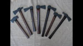
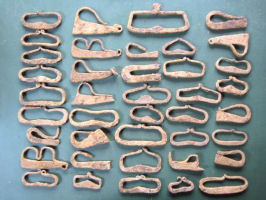
Since there has been a large number of axes turn up I feel it is a good idea to look at colonial trade axes. Trade goods have been present for centuries and it is important to be aware of this fact as we look at the items in this blog.
April 15
The thing about research is it always seems to keep turning up more information and the deeper one delves the more subjects are found that need to be further researched. What was originally a small project listing a couple dozen artifacts has now encompassed hundreds of items. Trying to find documentation on some upcoming subjects I found more items that we need to backtrack and look at. Also, I received a very exciting message recently. Here goes:
******
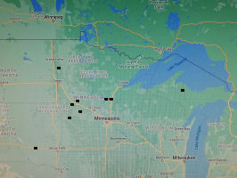
Holmes City, Minnesota
Boat 1938
The Minneapolis Tribune reported on April 3, 1938 of the finding of the rotted remains of a large boat on the north side of Grant Lake 12' above the water level. It had bowed ends. The find was reported by Holand. No further information is available at this time.
Holmes City is a small picturesque town on the north edge of Grant Lake. They are almost half way between Alexandria and the Kensington Runestone site.
Geographical location: 45.833, -95.549
PF 2-3
******
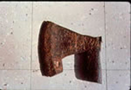
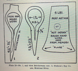
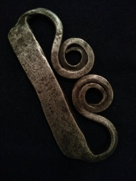
Mora, Minnesota
Axe 1920
I recently received an interesting e mail from a gentleman who reads this blog. I have copied it word for word other than editing some small parts.
My great-great grandfather (Otto Allman) was a farmer in Mora, MN and was the sheriff of Kanabec county for several years.
I write to you, because he also found what was believed to be a Viking era axe in Mora, Minnesota when breaking a new piece of land. The year would have been 1920.
From what I know it's now in the Carnegie museum.
Also included is the newspaper article that detailed the find.
Article Transcription:
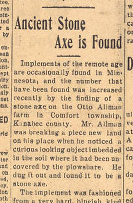
"Ancient Stone Axe is found -
Implements of the remote age are occasionally found in Minnesota, and the number that have been found was increased recently by the finding of a stone axe on the Otto Allman farm in Comfort township, Kanabec county. Mr. Allman was breaking a piece of new land on his place when he noticed a curious looking object embedded in the soil where it had been uncovered by a plowshare. He dug it out and found it to be a stone axe.
The implement was fashioned from a very hard, blueish kind of stone, weighs three pounds, and was perfectly proportioned and very smoothly polished. How the hard substance could be fashioned in such a perfect manner is a puzzle, especially, with the crude tools that must have been employed. The axe was made to be holding in the hand, instead of having a handle attached, as the extension to the part above the blade was plainly designed to fit the hand
It is not believed that these stone implements were made by Indians as they knew nothing of the art of making anything except arrow and spearheads from stone, when the early explorers first came to this region.
Mr. Allman is a well known citizen of Kanabec county, and is a director of the farmers' cooperative creamery at Mora. - Milaca County Times".
This axe is of an identical pattern to a number that we have already looked at with just slight enough differences to indicate it is also hand forged. A miscommunication occurred in calling this a stone axe. Perhaps it had a heavy patina originally from being burnt or such but later cleaned off. It is obviously metal. This error probably caused it to be overlooked in the general flurry of Minnesota artifacts that were turning up at the time.
In comparison to the other Mora axe that was found in 1933, the shape of the beard is distinctly different, the metal 'adjustment' plate on the back is smaller and the haft is at a lesser angle. The weight is consistent with the other axes of its type that have been found. 3 to 3 1/2 pounds.
In 1939 Curran reports a similar specimen in Lillehammer, Norway called the 'helmet crusher'. Also, The Norwegian Battle Axe is an article relative to our interests. Notice the extended socket or sleeve that the wood handle fits into as well as the angle the haft meets the axehead at.
Both axe finds are near the Snake River which flows into the St. Croix and subsequently the Mississippi.
Geographical location: 45.861, -93.219
PF 3-4
******
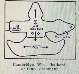
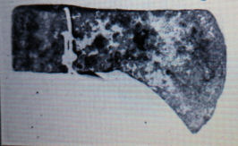
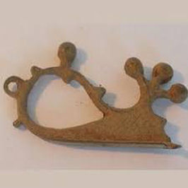
Cambridge, Wisconsin
Halberd, 1912
The drawing of this item is like the Minnesota halberds except for a rivet (screw) in the middle which is common on the earlier version of the American Tobacco Company Tobacco Cutter. The point also seems to shows something cut off where the flange would be attached on the cutter.
Geographical location: 43.008, -89.036
PF 1
******
Beardmore, Ontario
Update
*J. J. Jacobs was the name of the man who witnessed the rust marks of the sword in the stone layer.
*It was Professor McIlwaith who in 1937 found a piece of rusted iron that was said to be part of the shield boss. J. W. Curran witnessed the finding of another piece in 1938. They are housed with the other Beardmore Artifacts.
*Affidavits are present from many of the individuals involved in this find. Plates of affidavit are provided in Curran's book Here Was Vinland published in 1939.
Geographical location: 49.593,-87.964
******
Vinland Vignette
Here are some odd facts pertaining to Vinland that I came across while cleaning up some of my notes.
*The Bubonic plague reached Norway in the 1350s and recovery was in the 1360s.
*Guidrid Thorbjornsdottir, mother of Snorri Karlsefnison and wife of Thorfinn Karlsefni travelled to Rome on a pilgrimage in the 1020s after she became a widow.
*Erik, King of Norway in 1289 sent one 'Rolf' to Iceland to recruit men 'to go to the new land'.
*Reported by Adam of Bremen: King Sven Estridson of Denmark claimed that 'Vinland was a well known place from the many people who have travelled there and come back.
*In 1294 the Norwegian king made trade with Greenland a monopoly.
*In 1535 Jacques Cartier reported "Donnacona (of Quebec) has told us he had been in the country of the Saguenay in which are infinite rubies, gold and other riches, and that there are white men, who clothe themselves with woolen cloth, even as we do in France."
May 15
Since doing research on some of the upcoming artifacts and running across more information on the Beardmore finds, I think now is a good time to look at this man:
J. W. Curran
James Watson Curran (1865-1952) was the owner and editor of the Sault Star,a weekly newspaper out of Sault Ste. Marie, Ontario.
Born in Ireland, Curran came to Canada in 1873 and began working for his father's paper, the Essex Chronicle in 1881. He worked as editor for the Orillia News Letter, the Toronto Empire and the Montreal Herald before purchasing the Sault Star.
During his time in Northern Ontario he became a great friend of the First Nations peoples and Curran was given an honorary chieftainship in 1923.
His research into wolves resulted in his 1940 book Wolves Don't Bite and his insistence that these animals were over villified. During the depression he offered an incredible $100 challenge to anyone who could prove having been 'et by a wolf'.
In his examination of the Beardmore site Curran personally witnessed the finding of a shield boss fragment. He is mentioned in the Dodd affidavit.
In Curran's study of the Cree language he discovered their word for oak (wamistikose-watik) translated as wooden boat wood. As a point of interest, oak does not grow in the traditional Cree lands. He began the examination of 'loan' words in the different First Nations languages and looked into the "white indians" of Hudson Bay who apparently boasted features much like the Mandan of the plains.
Researching many of the other Norse finds around the Great Lakes, Curran propounded the theory that this was where Vinland was located and wrote Here Was Vinland in 1939. He suggested that the Norse of the sagas came through the Ginnungagap (Hudson Strait), down through Hudson Bay and James Bay into the Great Lakes area.
Curran even suggested the Irish were in North America before the Norse.Being quite far fetched for the period, now with Sutherland's findings in the north he seems to be not too far off course, much like Mowat with The Farfarers.
Coming at the outbreak of World War Two and being quite extraordinary for the time, his ideas were relegated to the back burner in lieu of the more traditional Christopher Columbus Viewpoint. Many of his theories and suppositions are very much in line with current thinking although Curran did miss the critical impact that the Minnesota finds make on his theory. Nevertheless, his contributions to the correct history of this planet should certainly not be overlooked.
******
Marquette, Michigan
Axe 1880
Reported to be of copper. No further information is available.
Geographical location: 46.543, -87.395
PF 2-3
******
Vinland Vignette
*Some interesting finds from the Lendbreen Pass, Norway. Thanks Terry.
*Viking steel contained the spirits of the dead. The bones of ancestors or in some cases valiant enemies were ground and incorporated into the sword making process. Of course carbon being a hardening agent, the improved metal certainly did have imbued mystical qualities. It would be interesting to learn just exactly what and how many bones were used. Are there any steel making experimental archaeologists with a couple skeletons around?
June 15
Kowkash, Ontario
Boats 1918
Here is a documented item of interest that may add credence to the Beardmore relics.
In 1918 F. W. Skully of the Dominion Police (absorbed by the NWMP to become the RNWMP) filed a report of examining two dilapidated boats of unusual construction deep in a swamp. Wood and nail samples were taken and sent to the National Geographic Society.
No reply was ever received by Skully and the current location of these samples is unknown but presumably somewhere at the National Geographic Society, if indeed they still exist.
Kowkash is under 100 Kilometers northeast of Beardmore. Nearby waterways link into the Albany river and subsequently James Bay. That early explorers became lost in the myriad of rivers, streams, lakes, muskegs and swamps of northern Ontario is quite believable. Just have a look at the google map of the area.
Geographical location: 50.243,-87.225
PF 3
******
....and a hundred years later:
Traverse City, Michigan
Runestone 2018
This Greywacke stone was found in Traverse City, Michigan in 2018 at a depth of 2' to 4' below grade level by a professional geologist, Darrell Potter. He was excavating for a house in a former orchard area on a hillside overlooking West Grand Traverse Bay that connects to Lake Michigan. This area could have been a pathway leading from the Bay inland to other locations.
Darrell reports:
"As a geologist I brought it home to use as a garden border. Since it was covered in a muddy exterior I hosed off the rock and cleaned out the rune with a nylon brush.
...The rock has a section broken off the top which looks like a single blow from a hammer or other device. This would show off the darker brown interior from the weathered exterior. This would make it stand out to notice by anyone seeing it. No other material was found at the site, with the exception of a mortar used to grind grains."
Darrell goes on to suggest some theories on the stone. Initially considering it might be a grave marker for a person with the initials IL he has also put forth the theory that this could be a marker from the Knudsen expedition in search of the missing Greenlanders. At a 180 degree angle rotation of the image the stone may show a hastily carved K and could have been left on a well used trail to signify that this area had been searched.
Darrell sent his information to Michigan State and the University of Michigan Archaeology departments and was told that there was no Norse presence known in this region.
In the photograph, the three marks at the upper left may be from the excavator and show the true darker nature of the stone. The brown color would be the stain from being buried. The cuts in the stone, especially the lower part, contain the discoloration of the rest of the stone so they are certainly not fresh. Also, there are some curved cuts on the lower portion of the stone that seem to be older than the runic cuts.
Norse? Earlier? Later? New World? Old World? This stone is certainly a prime candidate for further examinations and tests.
Anyone wishing to learn more about this find may contact Darrell Potter directly at: alpha-omega@prodigy.net
Geographical location: 44.763,-85.620
PF 3-4
******
Batchawana Bay, Ontario
Axe 1924
Less than 100 kilometers north of Sault Ste Marie along the eastern shore of Lake Superior, this axe was found on an island in the bay. It was analysed and found to be made of very poor quality iron.
Last known location was the Royal Ontario Museum, now the Canadian Musem.
Geographical location: 46.927, -84.605
PF 3-4
July 15
After having checked some notes and doing a bit of 'googliting'a couple more items of interest turned up in Grand Traverse Bay, Michigan.
Grand Traverse Bay, Michigan
Rock carvings 1870
Documented by Ramsdell, Parker, Buchanan. No further information at this time. These may be the same as the underwater finds of a mammoth petroglyph and stone structures however.
Geographical location: 45.088,-85.630
PF 2-3
******
Grand Traverse Bay, Michigan
Sunken Port 2021
If one examines this intriguing image the desire to become an underwater archaeologist emerges. What appears to be a sunken dock or line of buildings can be seen with what seems to be a 35' longship partially buried nearby. Another larger ship (?) can be seen at the lower right.
If I ever take up diving I think I would check this place out. As a matter of fact, the entire Traverse Bay area warrants examination above and below the water.
Geographical location: 44.899, -85.542
PF 2
******
Gros Cap, Ontario
Spearhead 1938
This 13" spearhead was found on an underwater ledge by Arnold Perri and Lloyd Cook on the east shore of Lake Superior. While they were swimming they discovered the point beneath some rocks. The spearhead was taken to Curran who documented their find. Current location is unknown but I would suspect it is in the Canadian Museum.
Geographical location: 46.534,-84.593
PF 3-4
August 15
Goulais Bay, Ontario
Firestriker 1939
Described as being 3 1/4" x 2" and of flat iron badly rusted. The firestriker was broken during cleaning. It's current location is unknown but possibly in the Canadian Museum.
Geographical location: 46.707, -84.478
PF 3
******
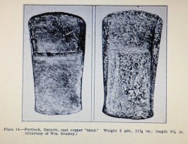
Portlock, Ontario
Copper Spud 1923
A spud is a form of socketed axe. They are a very common occurrence with the Copper Culture of the Great Lakes area (7500-500 BCE).
J. W. Curran however was of the opinion that this particular piece was Norse since the spud was cast and considering the circumstances of its find. He made a very convincing argument that the Norse would use any resource they would find and this area is bountiful in copper.
Geographical location: 46.341, -83.890
PF 2
******
Copper Island, Ontario
Sword 1938
In 1938 a J. G. Molinski reported finding a sword like the Beardmore relic in a gravel bed while skidding logs. No further information is known.
Geographical location: 46.318,-83.972
PF 2
******
Vinland Vignette
I have a new hobby. Googliting. Using Google Satellite images to search areas of interest and I am not the only one. This is a way to turn up some amazing finds. Look at what they are doing in Egypt with more pyramids and the most amazing diggings at Saqquara.
When I hear of artifacts, sites, stones, markers etc. one of the first things I like to do is look at the site and what is available for water in the area. Watercourses give us some answers to where and what the Norse and those more ancient were doing there.
Granted watercourses will change over time but in a few instances I found that less than the length of a football field separates the waterways of the Mississippi from those of the Great Lakes.
Here is one I tracked: Mississippi River - St. Croix River - Kettle River - Moose Horn River - 300 Feet - Black Hoof River - Nemadji River - Lake Superior.
There are more routes to look at if one is inclined to do some tracking. Also, for our immediate purposes the waterways from Hudson Bay to Lake Winnipeg, Winnipeg River to Lake Superior, Lake Winnipeg down the Red River to it's base running into the Whetstone River, Cedar River (Iowa) towards Kensington, Buffalo River (Minnesota) towards Kensington, Lake Superior towards Kensington and Lake Superior to James Bay all have significance to our story.
September 15
I think it is important to look at a few additional items that have emerged in the west since I started this blog. This first one is quite extreme and brings up the question: Did the Norse actually find a northwest passage?
Seattle, Washington
Runestone 1928
In 1928 Professor Oluf Opsjon claims to have read markings on a stone found within the city limits that described a battle where 12 Norsemen were killed and subsequently buried. The same Opsjon in 1919 claims he discovered lore about a fight between 31 Norse and the Clallarns, a local native tribe that occurred in AD 1010.
At the time, with the KRS having much dispute as to its genuinity and with the contemporary mindset, obviously Vikings on the west coast would be unheard of and met with complete scepticism.
Geographical location: 47.613, -122.482
PF 1-2
******
Prince Albert, Saskatchewan
Adzes 1956
2 Adzes similar to those displayed in the Royal Museum, Copenhagen were found deep in the ground in 1956. Current location is unknown but possibly the Prince Albert Historical Museum.
Geographical location: 53.216, -105.741
PF 2-3
******
Leaf Rapids, Manitoba
Runestone
In one of his books Hjalmar Holand relates about a very old and intriguing tale told in northern Manitoba. White Man Writing On Rock is supposed to be located at Leaf River Point. There is no Leaf River in Manitoba but there is a Leaf Rapids along the Churchill River system.
Geographical location: 56.462, -100.010
PF 2
******
Warren Landing, Manitoba
Mooring Stone
Reported by Holand. No further information is available.
Geographical location: 53.696, -97.872
PF 2
******
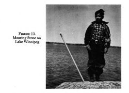
Berens River, Manitoba
Mooring Stone
This stone is situated on an island at the mouth of the river. Berens River is 75 miles southeast of Warren Landing. Under normal conditions this distance would be considered a 'daghrise'or day's journey.
Geographical location: 52.349, -97.019
PF 3
October 15
Husavik, Manitoba
Runestone 1925
A 3'x3'x5' stone of Dolomite was found in 1925. There were 20 runes carved into it. Scholars managed to interpret one word - riki=state. The current location is unknown but from the size description it should be at the site.
Geographical location: 50.563, -97.004
PF 2-3
******
Sandy Hook, Manitoba
Runestone 1933
A stone found in 1933 was said to contain 3 lines of runic markings. It was examined and photographed by individuals at the University of Manitoba where it was declared they were not runes but weathering. This stone was last known to be at the home of E. B. Gibson, Winnipeg photographer in 1938.
Sandy Hook is about 5 km south of Husavik along the west shore of Lake Winnipeg.
Geographical location: 50.542, -96.999
PF 2-3
******
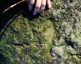
Camp Morton, Manitoba
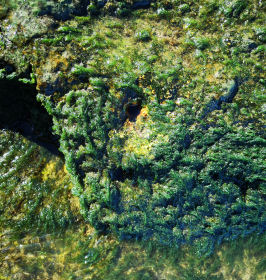
Mooring Stone
Just north of Camp Morton is a partially submerged stone with a hole that appears to be man made.
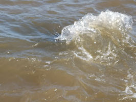
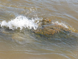
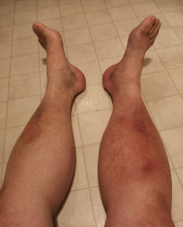
It was brought to my attention at an SCA (Society for Creative Anachronism) function by a gentleman who overheard me discussing mooring stones. I rushed to the site and tried to examine it.
Unfortunately it was a windy day and the waves very choppy. I only ended up with badly bruised legs.
A return trip on a calm day was more successful and I was able to locate and photograph the hole. It was heavily encrusted with lake algae making it quite difficult to determine exact size and depth. It was set at a 45 degree angle in the stone. My attempt to remove algae only showed heavier encrustation underneath. It prodded softly at about 4 inches depth indicating fill that could possibly be carbon dated.
As a point of interest directly across the lake from this stone is the Winnipeg River, the Northwest Company's traditional route to the east. This river flows into the Lake of the Woods and subsequently Lake Superior.
Geographical location: 50.735, -96.986
PF 2-3
******
Here are two interesting points to note:
The lower portion of Lake Winnipeg was heavily settled by Icelandic immigrants in the late nineteenth century. The area is known as 'New Iceland' and to this day Gimli, Manitoba is host to North America's largest Icelandic Festival. Unlike in Ohman's case with the KRS, it is more likely contemporary runestones in this area might be carved by local fishermen or their descendants.
******
Using approximately 75 miles as the distance for a daghrise we find one daghrise south of Berens River is Hekla/Grindstone Provincial Park and another daghrise gets you to the Forks in Winnipeg, a trade and meeting place for thousands of years.
Going north from Warren Landing in units of one daghrise we have Cross Lake,Mouth of the Nelson River,Kelsey,Gillam,Hudson Bay.
Can we use this as a basis to locate other mooring stones in the north?
******
Vinland Vignette
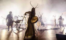
Although we have no way of knowing the actual music played by the Norse we do have documented finds of musical instruments as well as much of their poetry. Drums, rattles and flutes were common as was a stringed instrument called a tagelharp. An instrument commonly associated with the old west, the mouth harp (once referred to as a Jew's harp) possibly originated with the Vikings.
We also have many musically talented people that have the hearts and minds of an experimental archaeologist. Using replica instruments of the times they are creating their own concepts of Norse and Pre-Norse music such as the Skalds in the longhouse would have done a thousand years ago. Many pieces are based on Norse mythology, the Poetic Eddas and Elder Futhark runes which originally had magical annotations.
One of the first to make the spotlight was Danheim who might be considered to be the grandfather of the recent evolvement of Norse and Pagan music. His music was used a number of times for the soundtrack of the television series Vikings.
Another group, Wardruna, from Norway, is on the Vikings soundtrack as well. Their lead singer, Einar Selvik, in an individual effort is putting a different twist to this music by using modern instruments such as electric guitars.
Maria Franz from Germany does Norse and Pagan rituals on stage (concerts) with the group Heilung while playing more traditional music with Songleiker, a trio.
From Siberia we have Nytt Land who not only do Norse but northern European pagan. Their rituals on stage are quite spectacular with their unique version of throat singing.
Eivor Palsdottir from the Faeroe Islands is known for the soundtrack from The Last Kingdom. Eldrim, from Denmark uses seafaring voyages and raids as a basis for their conceptual album. Other artists of mention are Munknorr, Forndom, Vevaki, Nemuer, Fuimadane, Gealdyr and Asynje with more groups appearing as time goes on.
As an audiophile whose tastes encompass classical, bluegrass, rock and other types of music I find the evolvement of Viking and Pagan Music in the last decade to be another part of history. Also, I enjoy listening to it.
November 15
Synopsis of the Graenaveldi
At this point I am going to temporarily stop the examination of artifacts. We will continue with their trail further on. I certainly did not think that initially when I began this project over ninety listings would be put up in this small area alone.
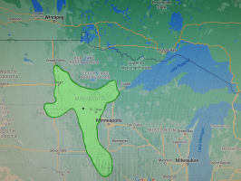
The area bordered by the Red River to the west, the Mississippi River to the East, the Great Lakes/Lake of the Woods to the north and the Cedar River with its tributaries to the south encompasses what could be considered the Norse territory of the Graenaveldi. (Map 1)
I have adopted the name of this territory from the book The Last Kings of Norse America by Robert G. Johnson and Janey Westin. They in turn sourced it through Jon Duason, an Icelandic historian and his reference to a quote from Sturla Thordarson of medieval times.
To clearly grasp what they were doing in North America, one has to think like a Norseman.
Exploration
The 'Vikings' were a seagoing culture who had a penchant for following waterways with the purposes of discovering routes, trading or raiding and potential settlement. It is a documented fact that these northern people made it as far south as Africa, served as bodyguards to the Emperor of Byzantium and had trade connections with China. They established the cities of Kiev and Novgorod as well as the province of Normandy. Clearly the established chain of events show they made their way to the new world via Iceland and then Greenland.
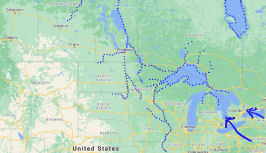
There are indications that there could have been explorations of this midwest area of North America as early as the ninth century. The Beardmore relics appear to date around the millenium (AD 1000) as do a number of other artifacts we have examined. Traces of exploration can be seen along many of the waterways connecting North America. (Map 2)
As shown to us by the sagas, once word got out about an explored area, traders and settlers would follow. Then exploration would continue on to farther reaches as well as seeking shortcuts in established routes.A prime example of adjusted routes is the Rus (Swedish Vikings) who originally established routes to Byzantium via the Volga River to the Caspian Sea and then later shortened these routes by accessing the Dnieper River to the Black Sea.
In our case there were two original routes to the Graenaveldi.
One was from the Ginnungagap (Davis Straits) and the northern Jorviks (trade centers) into the Indrawing Sea (Hudson Bay). From there the Churchill River system leads into Lake Winnipeg and then down to its base and the Whetstone River in South Dakota. The KRS tells us of a ship waiting at a haven 14 daghrise in distance from it which most experts have agreed is somewhere in Hudson Bay. Diverting from the Red River is the Buffalo River which leads towards Kensington.
The second route to the interior was clearly through the Great Lakes from Vinland on the east coast. We have a noticeable trail of artifacts that back this up. Many waterways at the base of Lake Superior then lead inland and in some cases less than the length of a football field separates the waterways of the Mississippi with those of the Great Lakes.
As time went on shortcuts would have been looked for. From Lake Winnipeg the Winnipeg River system leads to the Lake of the Woods and from there to Superior. Another highly sought shortening of route would have been from Lake Superior to James Bay although I have doubts that this was ever successful. All one needs to do is look at the myriad of waterways in the muskeg north of Lake Superior.
Typical Viking exploration would follow main waterways then backtrack up tributaries. In our case the Norse went southward down the Mississippi and and back up the Cedar River.
Trade
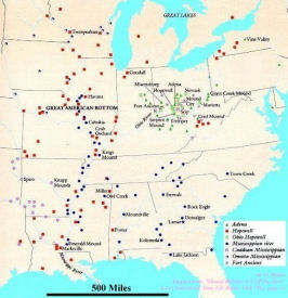
There was already an extensive trade network in North America before the Vikings arrived. Numerous large centers such as Cahokia and Aztalan, devoted to worship and trade, mainly along the Mississippi, had been present for centuries. It is very likely the Norse visited and participated in trade with them. There is significant evidence that they were involved with the native peoples further to the east. There we see glass beads, metal items, burins from the far north and even a coin. (Map 3)
In the west however, although local copper finds abound and we find metal artifacts scattered about the Graenaveldi, there is a significant lack of iron items present at any of the Mississippian Culture centers. A key explanation comes from the original Vinland sagas. Both tell of Karlsefni forbidding his men from trading metal weapons with the Skraelings. Clearly the cunning Norse would not pass off a technological advantage such as iron to a stone age culture. I'm sure if we met aliens, they would not readily give us warp drives or death rays.
The Graenaveldi was chosen partially because of its strategic location. We can see the area has easy access to the north via the Red River, the south via the Mississippi and the east via Lake Superior.
Many theorists consider the return of a portion of the Knudsen expedition to Norway to be significant. In their journey to the Graenaveldi and their return they have effectively encircled a large volume of land that can now be claimed by the King. This will be examined in more detail later when we get to the east.
Settlement
When we think of settlement we think of towns and cities but in the case of the Graenaveldi this is not so.
If these are indeed the descendants of the missing Greenlanders they would have settled as their ancestors did in Iceland in widely scattered self sufficient farmsteads. Disavowing a single ruler they would have governed themselves by an annual Althing.
In our case the heroes of our story are not only looking for choice land but good clean water which is quite easily found along the many tributaries of their main routes of exploration. In the east the Cedar River, in the west the Whetstone River and in the middle of the area the many waterways of central Minnesota.
This territory became the Graenaveldi.
******
Vinland Vignette
Was Freydis Outlawed?
Freydis Eiriksdottir, the bastard daughter of Eirik the Red is described as going on a resource gathering venture to Vinland in partnership with two brothers, Helgi and Finboggi out of Iceland. When she returns without the brothers Leif becomes suspicious and, under torture, some of her men relate that the Icelanders and their crew had been massacred on the order of Freydis and her husband Thorvard.
From the Saga of the Greenlanders: 'I am not the one to deal my sister Freydis the punishment she deserves.' Leif said, 'but I predict that their descendants will not get on well in this world.' As things turned out, after that no one expected anything but evil from them.
A different version of the Groenlendinga Saga: 'I like not,' said Leif, 'to do that to Freydis, my sister, which she has deserved, but this I will predict, that thy posterity will never thrive.' Now the consequence was, that no one, from that time thought otherwise than ill of them.
I don't believe this is only a Norse habit but I do know there are many who, when dealing with unpleasant people, will avoid or shun them and isn't that a form of outlawry?
Since Eirik the Red had property at Lysufjord in the Western Settlement of Greenland, it is conceivable that this is where Freydis ended up with her fleet of at least 2 ships, immediate family and supporters. We hear nothing of the Western Settlement after the Vinland sagas until the disappearance of its residents is noted by Ivar Bardarson in 1341.
In The Bishops of Vinland, a very obscure Catholic church reference from the 1890s, there is a Thorvard listed as Bishop of Vinland in 1050. Could this be a descendant of Freydis and her husband? This reference is not to be confused with The Bishops of North America, a reference from 1895 which first lists Eirik as Bishop.
A point to consider here is: Would not an influx of settlers in 1050-1100 be a reason for the expansion of Vinland and the establisment of a bishopry?
December 15
Footprints of the Graenaveldi
A look at the artifacts found in the area of the Graenaveldi can also give us clues as to what happened. Although in future some of these relics may be discounted as later colonial era trade items it would be necessary to discount every single one of them to successfully dispute the theory of this Norse territory, especially as more and more items continue to turn up and are dug out of archives.
There are three factors to look at when examining the footprints of this area. First, the disperal of military artifacts. Second, the dispersal of generic artifacts. Third and of high importance is the Kensington Runestone and the dispersal of mooring stones. When I state military artifacts I am specifically referring to those of the ill fated Knudsen expedition in the fourteenth century.
Fourteenth Century Military
I have classified the halberds, the bardiche and designated five of the axe heads as fourteenth century military based on the style, similarity of manufacture and the likeness of metal calibre. The way they are dispersed indicates possible native captures from the Knudsen massacre. Some of these items show patterns of wear that would correspond with being taken, used and discarded. (Map 4)
Of principal interest are the five battle axes I have classified here. Although of identical style they are uniquely different and are all hand forged. They are the axes from Erdahl, Milan, Mora 1933, Republic and Mora 1920. The Cormorant Lake axe is classified elsewhere with a number of other axes as it is of a slightly different pattern.
The first impression one gets when looking at any of these axes is how big, thick and awkwardly brutal they are. But then, we must consider that these were the days of knights and full plate metal armor. These axes feature varying degrees of tilt specific for combat blows as well as fully socketed hafts common with known later patterns of Norse battle axes that evolved to become lighter.
Curran claimed these axes were identical to one called the 'helmet smasher'on display at a museum in Lillehammer, Norway.
A determining characteristic that most of these axes have is a small metal plate on the back. The Erdahl and Mora 1933 have large plates, the Mora 1920 has a mid size plate, the Milan axe has a tiny plate while the Republic axe has none at all.
Why the plates and why the difference in size? The first clue was that these axes each weigh in the neighborhood of 3.5 pounds. So then these metal squares at the back of the axes were added for uniformity of weight? Not quite.
Our next clue comes from metal breastplates of the eighteenth and nineteenth centuries. Many will show a bullet mark or a repaired bullet hole. These are done at the ordnance department as a method of testing the strength of the armor.
I believe these Norse battle axes underwent rigid testing of their own and the adjustment plates added so they could meet their standard or as one of our more favorite 'Forged in Fire' personalities says, 'so this will keel'.
Quite significantly the bardiche also contains a metal plate that relates it to the axes.
The two halberds on display at the Alexandria museum, although found at different times and places, are clearly of identical manufacture and similar in metal quality to that of the other weapons here. The Knox halberd, viewed only by photograph, needs further research.
Generic Artifacts
In this category we have placed all the numerous generic artifacts, locations and heresays that we have examined. Small knives, fishing spear tines, firestrikers and axes are listed here. I have also classified the spearheads in this grouping although the Windjue spear may possibly be related to the military finds listed above. (Map 5)
Some of the other axes found in the Graenaveldi are of a style that has been used for 2000 years all the way into the nineteenth century. In Norse fashion many of these would be multi purpose. Axes could be used either for battle or cutting wood.
It is important to note that firestrikers and axes were a common fur trade item for hundreds of years. Check the photos of trade axes posted previously. Some comments need to be made on the firestrikers.
The climax firestriker discovered in 1870 along the Red River is of a similar pattern to those used throughout the fur trade era. This artifact however has found identical matches in the University Museum of Oslo, where it was once housed. It was found at a strata depth of 2 feet near the Red River. Note the Frog Point halberd was found further downriver along the bank also at the same strata depth.
The Cormorant Lake firestriker is of a noticeably different style. I am quite familiar with this type as a Norse pattern. Pairing with the axehead this find appears unrelated to the Knudsen massacre and I suspect the loss to be that of an earlier explorer or settler. Perhaps a boat overturned.
The Labelle firestriker remains a mystery as it is not a usual Norse shape. It is three dimensional. An examination of firestrikers from Novgorod do indicate unusual shapes but all of a two dimensional aspect. My search of images found only one other three dimensional firestriker and that turned out to be sixteenth century English. Should the Labelle artifact indeed prove to be English from this timeframe we start up a whole new investigation. Can we be dealing with missing Roanoke colonists who moved westward? Henry Hudson? A trade item? A battle trophy? Let's not open this can of worms.
All in all, the patterns of the finds show a concentration in the area of the Graenaveldi as well as a scattering along waterways indicating routes or exploration of possible routes.
This brings up our third category:
KRS and Mooring Stones
The large number of mooring stones in the Graenaveldi as well as those at and around the KRS site is an indication that somehow or other they are related to the runestone and its story. (Map 6)
It is clear the Knudsen expedition (1361-1364) was looking for someone. Did they make the mooring stones or were they just following them? Maybe it was both.
Perhaps Knudsen was following known trade routes or markers. Years ago we went fishing to Lac La Ronge in Northern Saskatchewan. This is a very large lake with myriads of islands and channels. It was neccessary to use a detailed map that synchronized with markers on the shore to know our progress, otherwise we would have been hopelessly lost. (Curiously, just as an aside, I wonder how long these markers would last?)
Yet strangely we find many of these stones in areas that are not close to water and some that are quite elevated. Some good examples are Skrall Hill and other hills surrounding the KRS site as well as those in the whetstone river area.
A standard on a hilltop could be seen from quite a distance.
Most of the Old World Scandinavian uses for mooring stones was to affix an iron ring and use them to tie up boats but the Icelandic Gragas gives us a different use, that of property markers. The mooring stones not only trace paths but a large number in any given area can indicate a potential concentration of land takers. Perhaps they also marked temporary sites.
******
Vinland Vignette
*In 1345 a journal entitled Chronica Universalis written by Galvaneus Flamma makes a reference to Markland and describes it as rich in lumber. He apparently learned this from Genoese traders. Note that Christopher Columbus was in Genoa for a time.
******
Some interesting finds in South America:
*In Peru the mummified remains of over 1000 dogs have been found in many burial sites, some of them with humans. Although this is not surprising in itself, what does draw attention is the DNA testing that determines them to be Danish Sheep dogs. The mummies date between AD 1000-1250.
*Numerous runes have turned up in Paraguay.
*The Inca King Ipir was reported as white skinned, blond and bearded.
*There has traditionally been a cover-up by the Brazilian and Bolivian governments in regards to PCE contact. Could this be due to Nazi backing during World War Two? In 1943, during the critical Battle of the Atlantic, the Nazis used an important military resource, a U Boat to deliver archaeological supplies to Argentina.
Verified from another source: Ancient Origins Magazine
******
National Geographic Article
I was pleased to learn about the recent National Geographic article that has placed a date of 1021 on a piece of wood found at Kjalarnes (L'Anse Aux Meadows). This is a pleasant indication of how modern technology is being used to unravel our PCE history correctly. The big question now is: Was this from the voyage of Thorvald Eirikson or Thorfinn Karlsefni?
In Kjalarnes Found, I detailed how there were three longhouses built there. Two were built by Thorvald Eirikson (DE and FG) and a third, originally built as a smithy, later added on to by Karlsefni (ABC). If there is enough left of the longhouse posts this dating technique might be used to place our Viking explorers or colonizers precisely. We should be able to pinpoint within two years the precise date of Snorri's birth.
******
I have personally altered my stance on archaeological digs. There is now no hurry to dig. We can let future technology do it for us. It will eventually advance to the point where we will know in precise detail what is there before we even touch it so that the least amount is disturbed. I pray I will see some of this in my lifetime.
*************************************************************************
May I wish everyone a happy and joyful Yule, Christmas, Hannukah, Eid, New Year and all others I missed.
*************************************************************************
....to be continued.