Vinland Blog 2023
Introduction
I have always been interested in the Vikings, especially their visits to North America and the encounters with the natives (Skraelings). As if to spur this on, I was commissioned to build a model of a Viking Longship for our Local Scandinavian Cultural Center. Near the same time I obtained a copy of the book Westviking by Farley Mowat (1965) and after reading it, we decided to take a vacation to Newfoundland where L' Anse Aux Meadows, the only verified Norse site in North America is located. What I learned in Newfoundland and the subsequent results of my research is remarkable.
Archive 2011-2017
Archive 2018
Archive 2019
Archive 2020
Archive 2021
Archive 2022
Back to home page
|
Probability Factor
PF1. Not likely. Prove to me that it is.
|
|
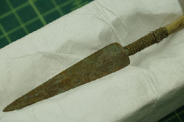
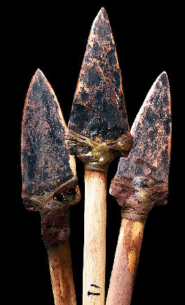
| Copper Culture spearpoint similar to type found in the Yukon |
|
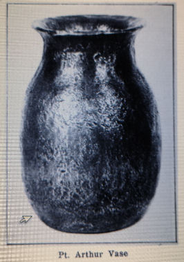
| Copper Culture vase in Milwaukee Museum |
|
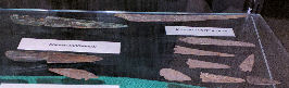
| Copper Culture socketed long knife or sword |
|
| Copper Culture weapons in the Runestone Museum, Alexandria (photo- author) |
|
| Copper Culture arrow points of flat style |
|
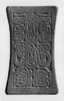
| Adena tablet from Cincinnati, Ohio |
|
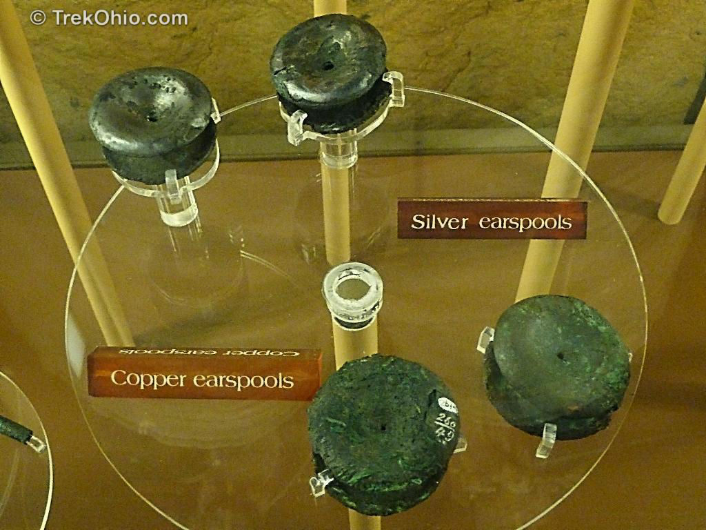
| Adena earspools, Mound City Group, Ohio |
|
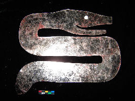
| Serpent made of Mica, Turner Site, Ohio |

|
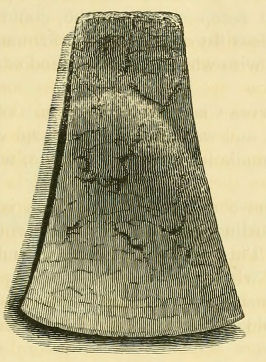
| Polished granite axe head, Spiro Mounds, OK, Mississippian Culture (photo - Author) |
|
| Engraved copper plate, Spiro Mounds, OK, Mississippian Culture (photo - Author) |
|
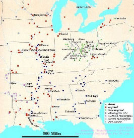
| Map of North American mounds |
|
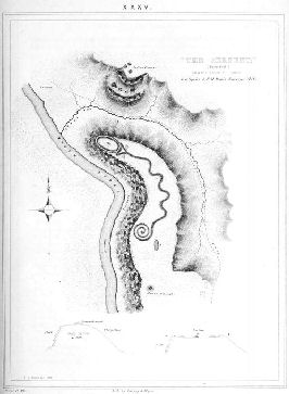
| Ephraim George Squier and E. H. Davis, "The Serpent;" Smithsonian institution, 1848 |
|
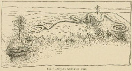
| A different view of Serpent Mound, Ohio |
|
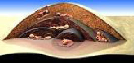
| A cutaway view of of a burial mound. |
|
| Grand Mound (Photo courtesy MN Historical Society) Rainy River, Minnesota |
|
| Rainy River, Ontario mound (Reproduced from Wright 1972a: Plate 13) |
|
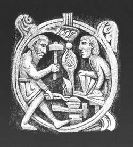
| Forging a sword (from the saga of Sigurd) |
|
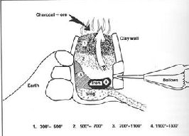
| Cutaway of an iron forge |
|
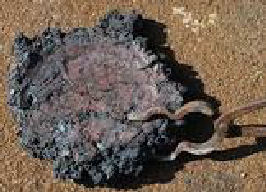
| Raw slag or iron. Note the tool. |
|
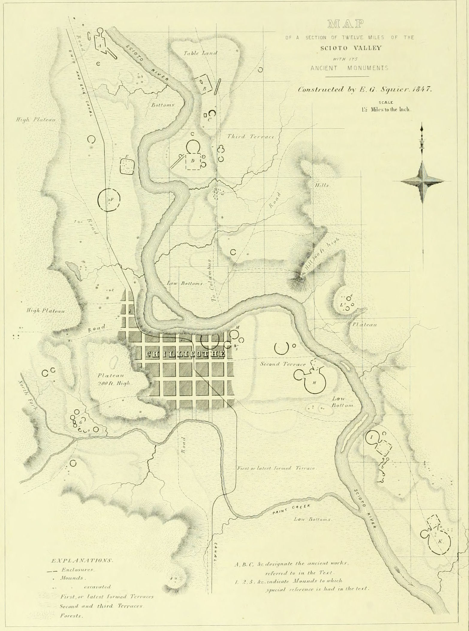
| Twelve miles of the Scioto River Valley indicating ancient sites (Map from Ancient Monuments of the Mississippi Valley 1848) |
|
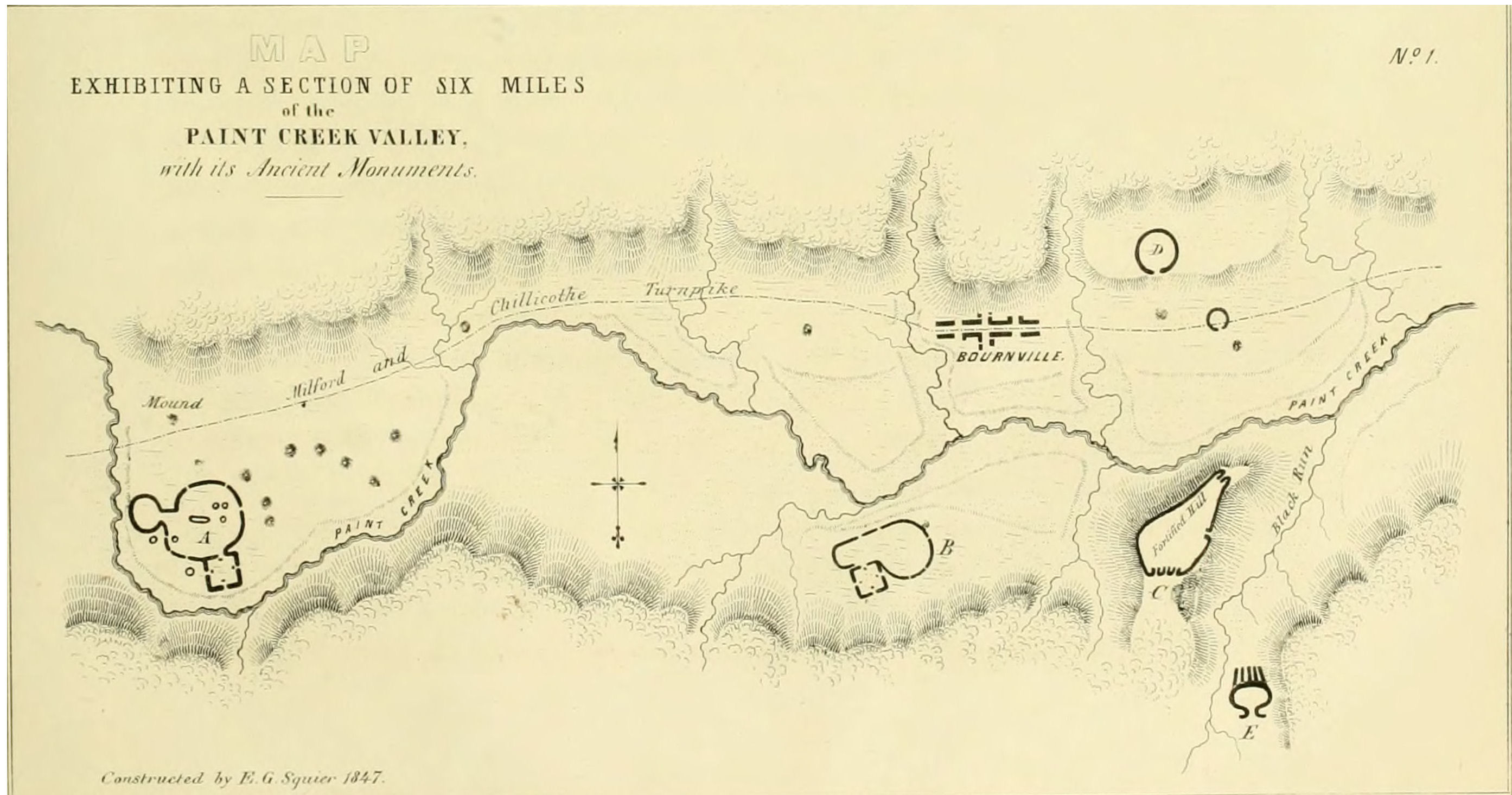
| Six miles of the Paint Creek Valley indicating ancient sites (Map from Ancient Monuments of the Mississippi Valley 1848) |
|
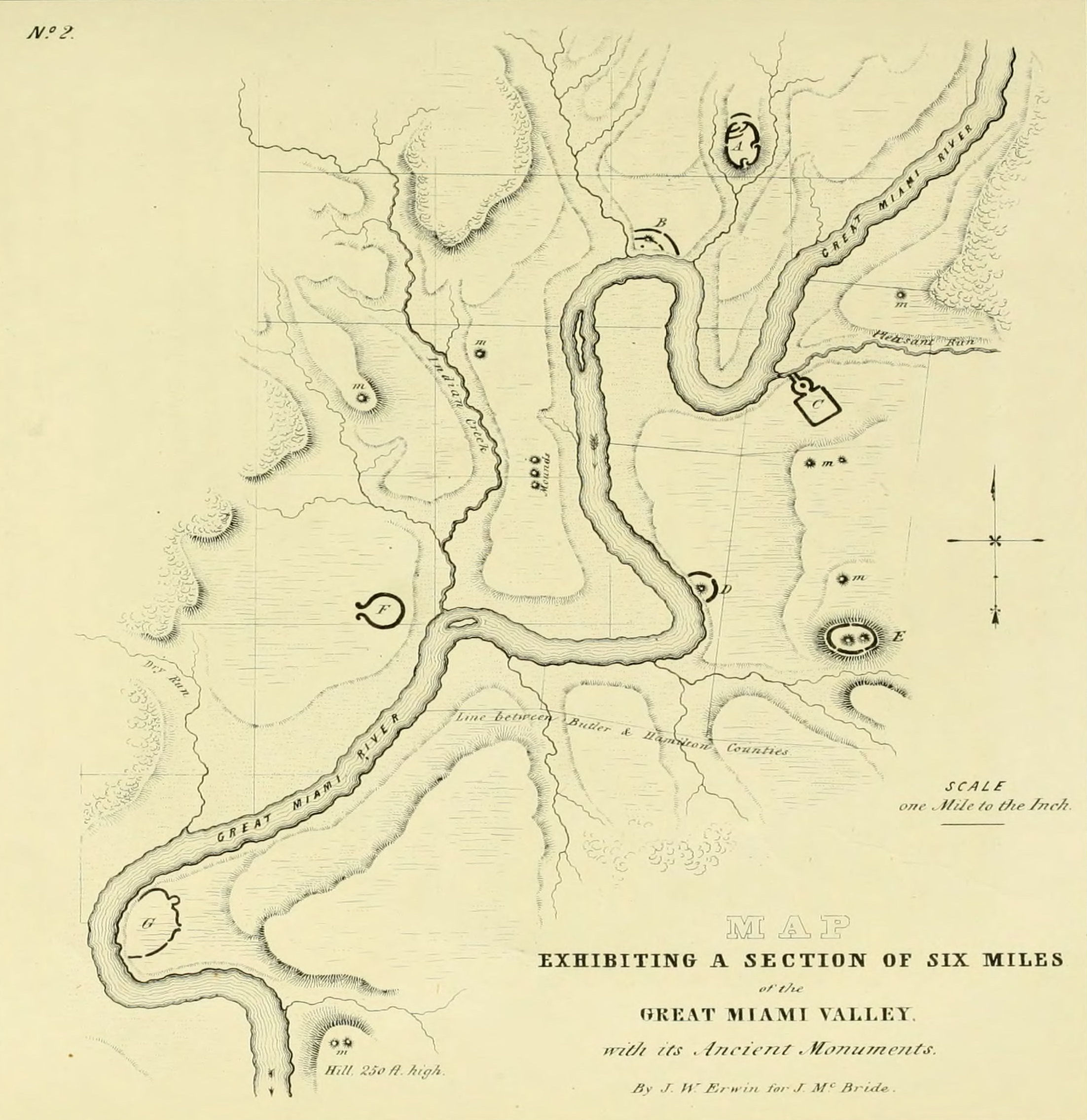
| Six miles of the Great Miami Valley indicating ancient sites (Map from Ancient Monuments of the Mississippi Valley 1848) |
|
| The Great Mound at Cahokia (photo Smithsonian Magazine) |
|
| Artist's depiction of Cahokia (Image courtesy of Cahokia Mounds State Historic Site) |
|
| Natural rock formations can sometimes be confused with man made structures. These are natural. (Photo used previously) |
|
| Artist's concept of the fortifications at Scott, Arkansas |
|
| Aerial view image of the fortifications at Scott, Arkansas (Democrat-Gazette file photo) |
|
| Animal effigy mounds at Horeb, Wisconsin (Map from Ancient Monuments of the Mississippi Valley 1848) |
|
| Animal effigy mounds at Riley, Wisconsin (Map from Ancient Monuments of the Mississippi Valley 1848) |
|
| Fortifications at Duck River, Tennessee (Map from Ancient Monuments of the Mississippi Valley 1848) |
|
| Fortifications at Manchester, Tennessee. Note different styles of stone work. |
|
| Trail map of the Manchester fortifications. |
|
| Satellite image of ancient fortifications, Fort Knox, Kentucky (Google Maps) |
|
| Old Photograph, Cherokee Park, Kentucky |
|
| Stonework, Cherokee Park, Kentucky (View 1) |
|
| Stonework, Cherokee Park, Kentucky (View 2) |
|
| Stonework, Cherokee Park, Kentucky (View 3) |
|
| Stonework, Cherokee Park, Kentucky (View 4) |
|
| Fortifications at Miami Township, Ohio (Map from Ancient Monuments of the Mississippi Valley 1848) |
|
| Fortifications at Midway, Kentucky (Map from Ancient Monuments of the Mississippi Valley 1848) |
|
| Fortifications at Coleraine, Ohio 39.308, -84.631 (Map from Ancient Monuments of the Mississippi Valley 1848) |
|
| Fortifications at Lexington, Kentucky (Map from Ancient Monuments of the Mississippi Valley 1848) |
|
| Fortifications at Hamilton, Ohio (Map from Ancient Monuments of the Mississippi Valley 1848) |
|
| Toucan pottery handle, Hamilton, Ohio (Illustration from Ancient Monuments of the Mississippi Valley 1848) |
|
| Fortifications at West Alexandria, Ohio (Illustration from Ancient Monuments of the Mississippi Valley 1848) |
|
| Fortifications at Stoners Creek, Kentucky (Illustration from Ancient Monuments of the Mississippi Valley 1848) |
|
| Fortifications at Piqua, Ohio (Illustration from Ancient Monuments of the Mississippi Valley 1848) |
|
| Fort Ancient Stoneworks, Washington Township , Ohio (Illustration from Ancient Monuments of the Mississippi Valley 1848) |
|
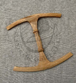
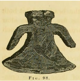
| Oseberg wool winder (Oslo museum) |
 |
| Nineteenth century woodcut of the Pollock Works |
 |
| An aerial image taken between 1960-1980 shows the full Serpent Mound site in Adams County, Ohio (Photo courtesy of Ohio History Connection) |
 |
| Copy of trail map brochure, Serpent Mound, Ohio |
|
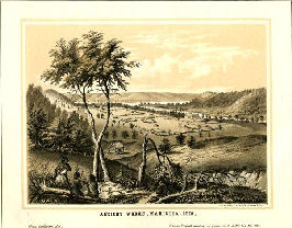
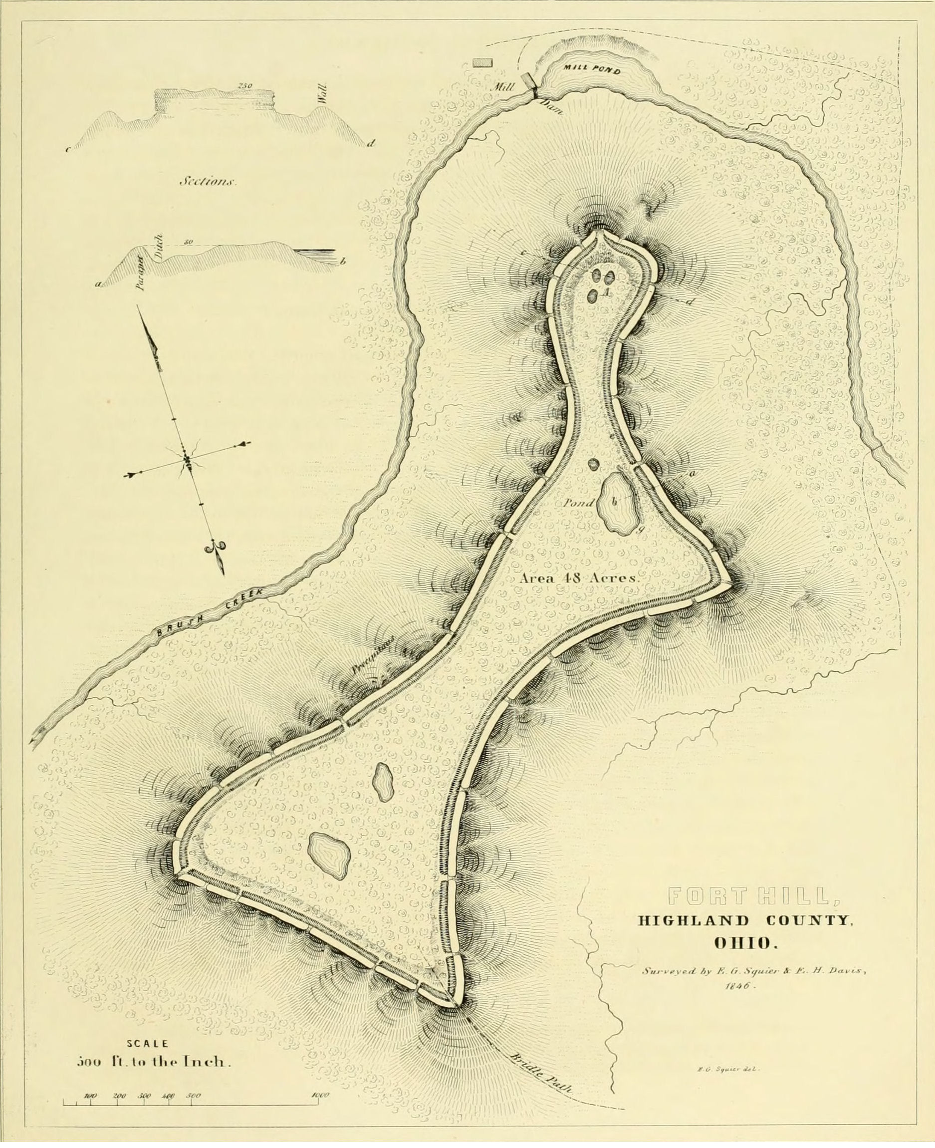
| Fort Hill Earthworks, Lincolnville, Ohio (Illustration from Ancient Monuments of the Mississippi Valley 1848) |
|
| Fort Hill Earthworks, Lincolnville, Ohio viewed from a distance |
|
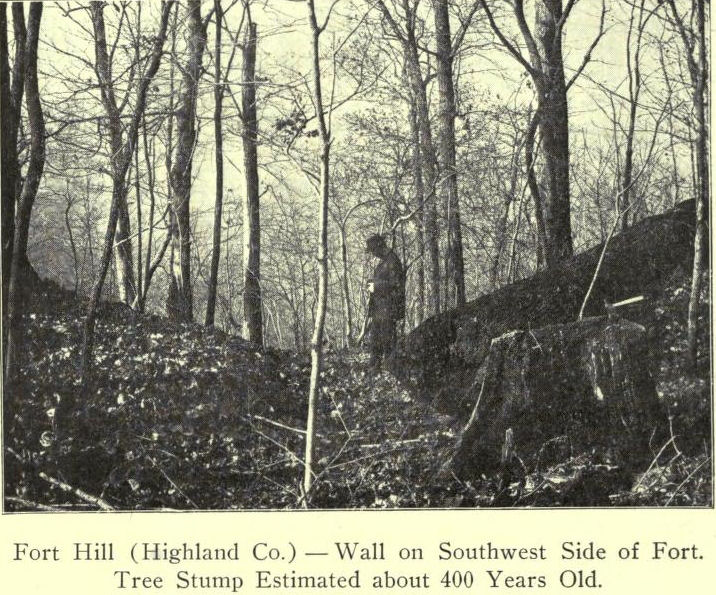
| Fort Hill Earthworks Old photo from "Masterpieces of the Mound Builders" |
|
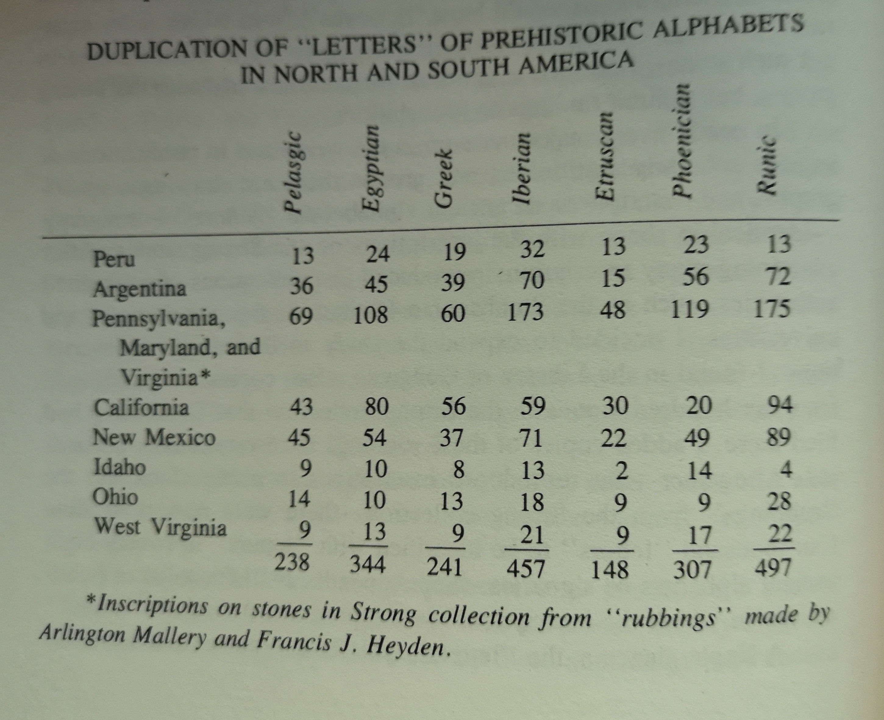
| Arlington Mallery's chart of duplication of ancient letters in North America |
|
| Spruce Hill Earthworks, Bourneville, Ohio (Illustration from Ancient Monuments of the Mississippi Valley 1848) |
|
| Inscribed stone at grave entrance, Spruce Hill Earthworks, Ohio (Photo from The Rediscovery of Lost America by Arlington Mallery) |
|
| Viking grave on Spruce Hill (Photo from The Rediscovery of Lost America by Arlington Mallery) |
|
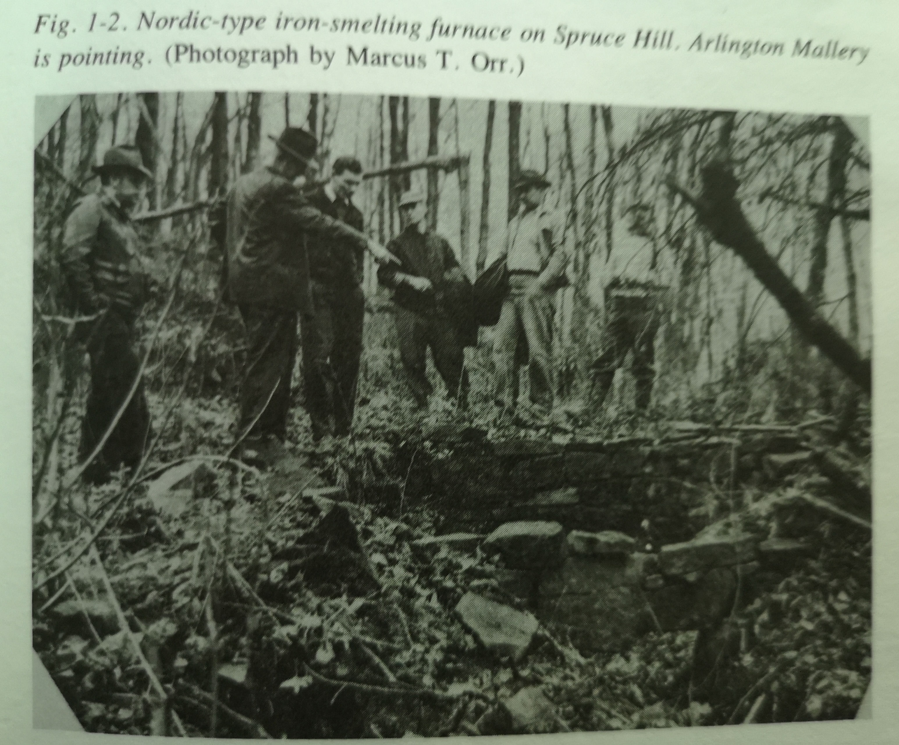
| Nordic type iron smelting furnace, Spruce Hill (Photo from The Rediscovery of Lost America by Arlington Mallery) |

|
| Imagine this coming out of the fog at you |
|
| Unknown structure in Seal Township, Ohio (Illustration from Ancient Monuments of the Mississippi Valley 1848) |
|
| The Allyn Mound, Franklin, Ohio (Illustration from Ancient Monuments of the Mississippi Valley 1848) |
|
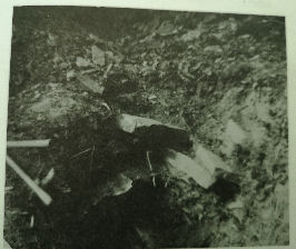
| Iron shovels found by Arlington Mallery in the Deer Creek Valley (Photo from The Rediscovery of Lost America by Arlington Mallery) |
|
| Arlington Mallery displays a number of iron bars and implements found in Deer Creek Valley (Photo from The Rediscovery of Lost America by Arlington Mallery) |
|
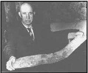
| A previosly posted photograph of Arlington Mallery holding the iron bar discovered at the Allyn Mound |
|
| An Axe found in burial at Chillicothe, Ohio (Illustration from Ancient Monuments of the Mississippi Valley 1848) |
|
| This lead axe or human figurine was recovered from the fortifications at Circleville, Ohio. (Illustration from Ancient Monuments of the Mississippi Valley 1848) |
January 15
A viking came home from pillaging to find that everyone thought he was dead. His wife, enraged, went to the village chieftain to complain.
The chieftain apologized profusely, saying: �I must have taken Leif off my census!�.
******
Even as I write this blog the Kievan Rus (Swedish Vikings) along with the Verengian Guard are standing strong in the shield wall against the Muscovites. It is interesting to realize the current war in Ukraine has traditional roots over one thousand years old. Hostilities started around the time the Swedes moved their trade routes to Byzantium from the Volga to the Dnieper rivers.
******
I am aware that this blog is supposed to deal with the Vikings and their relationships to North America. I also realize I have been covering some quite NON Viking subjects lately, but I feel it is also most essential to look at some of the identified native cultures in North America that were around before and during the Viking/Norse incursions. This is important as we begin to look at the central portion of North America.
We have already determined that the Norse were not the first visitors to this continent and that they were mainly following already well established trade routes but, their interactions with the native peoples they met are critically important and must be considered.
******
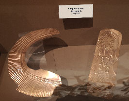
THE COPPER CULTURE
One of the most impressive and enigmatic of the cultures to come out of North America is called the Old Copper Culture. They emerged in an area from the northwest region of Lake Superior down into Lake Michigan and including western portions of the Michigan peninsula.
Recent radio carbon dating has confirmed the earlier dates put forward with the scientific study of magnesium and copper trailings from Isle Royale, this culture's major source of wealth. During their time over 125,000 tons of copper were taken from there. Some experts suggest this figure could be up to 750,000 tons. Current discussions focus around whether this culture smelted or only annealed this metal.
With Gobekli Tepi dating at 8000 BCE and excavations of sites at 12,000+ the concept of an advanced copper culture in North America at 7500 BCE can no longer be dismissed. We see the evolution of socketed weapons and tools that are at their apex around 3500 BCE. Long knives and swords are developed.
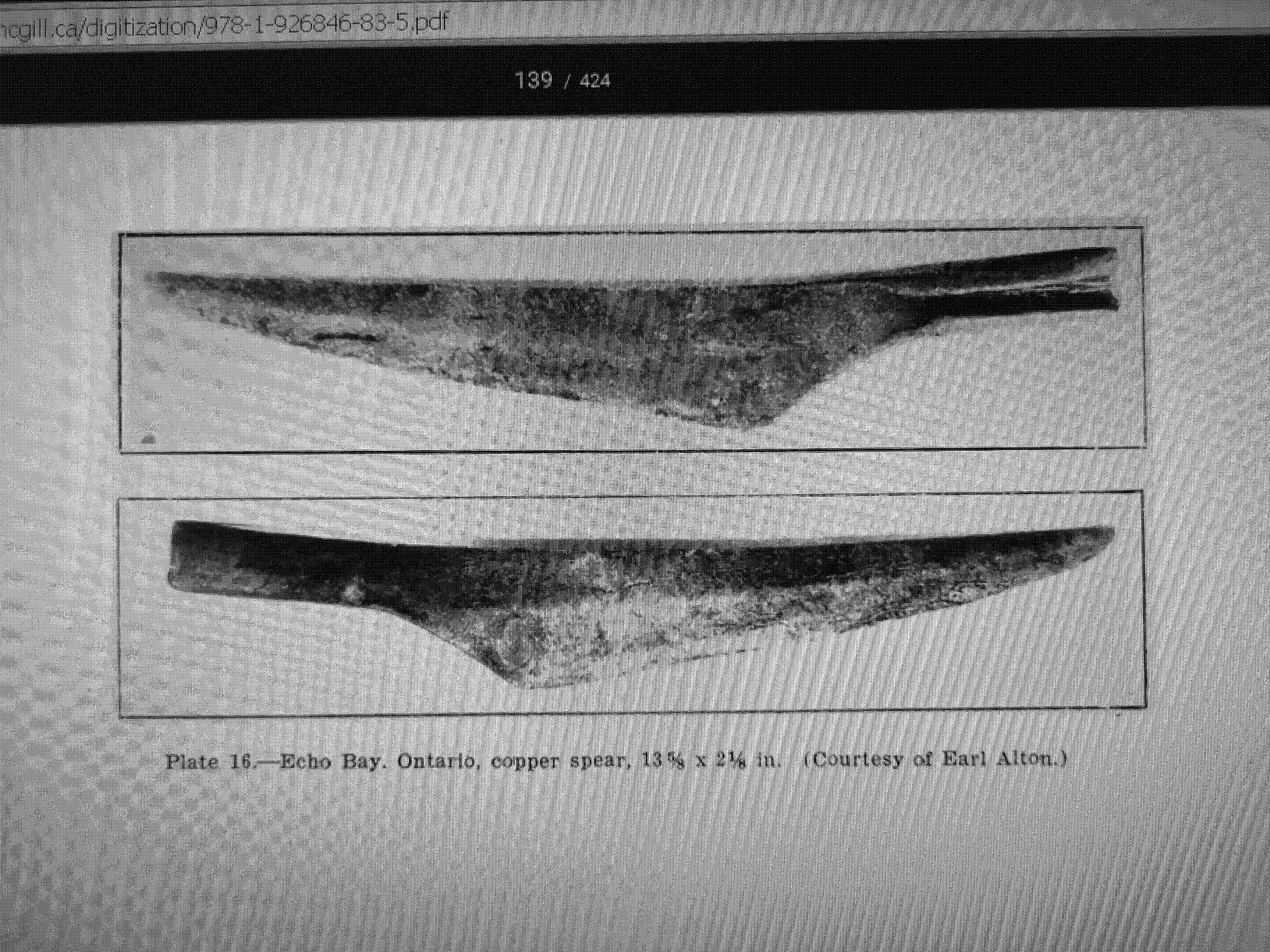
An article from the Fenwick Papers discusses North American Viking artifacts but also refers to some copper items. There is also a good picture of a Copper Culture sword at the bottom of this article.
Current thoughts suggest that massive amounts of copper (125,000 tons) were exported to the Old World where, combined with tin, helped the Bronze Age come to be. The fact is that we cannot account for even a fraction of that amount of copper in North American artifacts while the Old World cannot account for the amount of copper used during the Bronze Age. Copper ingots in ancient shipwrecks have been traced to the Lake Superior region.
Interestingly, a change in the Copper Culture is parallel to the start of the Bronze Age. By around 3300 BCE sophisticated copper weapons are found less while flat tang arrow points and ornamental items start to become more plentiful. A reduction in the making of these items seems to parallel the iron age even more at 1200 BCE.
By 500 BCE this culture is replaced by the Woodlands and Hopewell cultures although exports of copper from this area seem to have continued on well into the sixteenth century.
Here is an excellent article and good theories on the decline of the Copper Culture:
The remains of a prehistoric village was found at Lake Gogebic,Wisconsin. Copper arrowpoints and several awls or stylus were uncovered there. More important is Isle Royale itself where copper was taken from ancient mine shafts. Wood found in sockets of copper mining tools has been carbon dated to 3700 BC but not only copper was found. Obsidian and chalcedony points, human bones, skulls thicker than Aboriginal or European and a Medallion from India dating between CE 700-1300 were located in archaeological digs.
To give an idea of the extent of the Old Copper Culture's influence we find arrowpoints, spearheads, knives and swords from as far away as Carcross, Yukon while many artifacts have been found through Minnesota and Northern Ontario. In Green Bay, Wisconsin the Neville Public Museum displays a nice selection of Copper Culture artifacts that would probably bear having a good look at. The Museum in Milwaukee boasts 1500 artifacts.
Is it possible that early Viking explorers heard tales of great wealth in the new world and had to see for themselves?
February 15
A NEW FIND TURNS BACK THE CLOCK
A runestone of Ringerike style has recently been discovered in Denmark with sediment carbon dating to CE 0-150. The stone was carved in proper runic style which experts say indicates the language was in use for 200 years previous, extending the dating of Elder Futhark from CE 300-800 to BCE 200- CE 800. This indicates ELDER FUTHARK was used for an entire millenium!
******
Native cultures continued...
When looking at the following cultures it is important to note that the dating used is all approximate relying on the current accepted norms. The emergence and decline of these cultures was a gradual process that would have taken a number of generations on either end.
******
THE WOODLANDS CULTURE
The Eastern Woodlands culture is one of the two basic cultures to replace the Old Copper Culture. Emerging around 500 BCE, this is an unusual case that shows the people of the area devolved from the use of copper weapons and tools to using stone tools and although agriculture was practiced, the emergence of nomadic hunting practices occurred. Hammered copper is still present but more in the forms of ornamentation and jewellery.
Around CE 1100 the culture separated into some of the more distinct tribes we know today from post Columbus contact such as the Algonquin, Mi�kmaq, Ojibwe, Abenaki, Iroquois and Huron. Is it possible the Norse had something to do with this?
This article provides further details for those who wish to learn more about these people:
******
THE ADENA
The other culture to emerge from the Old Copper Culture is the Adena around 500 BCE. Divergently the Adena appear to be more static than their Woodland Culture contemporaries while the Adena's cultivation of crops is more plentiful. Copper is still used decoratively and in trade. Intricately carved effigy pipes are turned up in many sites. We hear of mounds.
More details can be found here:
There is a decline in the Adena around CE 100. It is most likely this group assimilated into the Hopewell Culture although there are possibilities they migrated southward. Perhaps both occurred. What is quite noticeable is how strikingly similar Adena artwork is to that of the Mesoamerican cultures.
Here is a great link with some excellent pictures:
(While researching the Adena artifacts at the above website I ran across a pair of silver earspools as pictured at right. They were dug out of the Mound City Group, Ohio. Although copper earspools are not uncommon, silver pairs are exceedingly rare. Sort of reminds me of King Tuts iron meteorite dagger. Bears looking into, but not by me.)
******
THE HOPEWELL CULTURE
The Hopewell Culture emerged around 200 BCE and are so closely related to the Adena that it is likely they are a sub-culture. Sharing many characteristics with the Adena such as copper, trade and crop cultivation.
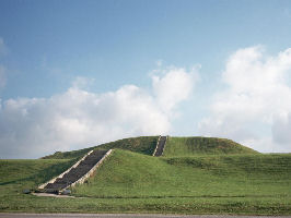
The Hopewell Culture is also reknowned for their mound building, again shared with the Adena. Later European settlers coming to this part of central North America encountered thousands of mounds. Many were destroyed while tilling the land. More were looted and some were dug properly by credited archaeologists. Very few remain today leaving us with a sadly unsolvable mystery.
The Hopewell Culture was in decline somewhere around CE 500.
A large volcanic eruption occurred in Ilipango(?), Guatemala in CE 536. A dense ash cloud hovered over the northern hemisphere for some time resulting in extremely inclement weather and starvation. The demise of the Mayan culture has been attributed to this event.
Could this also have been the cause of the end of the Hopewell culture or were there other mitigating factors?
Patricia Sutherland's finds in the north indicate a European people were there around this time frame. That they made their presence known further south is indicated not only by saga reports but by numerous sites and artifacts.
Byzantium, in this time era was also affected by this eruption but it was additionally hit by a bout of the Bubonic Plague. This eastern culture nearly collapsed because of these factors. This era is considered to be the end of the Classical Ages and the beginning of the Dark Ages.
******
THE MISSISSIPPIAN CULTURE
The Mississippian People must have encountered the Norse. Their emergence around CE 700 was a result of the rebuilding of a vast culture and trade network to replace that devastated by the events of CE 500.
They covered a vast area from north of the great lakes, west of the Mississippi and south almost to the Gulf of Mexico. Their eastern ranges were to the Allegeny Mountains and throughout the Ohio valley.
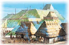
Again mound building was one of their specialties although this was more sophisticated into temples and pyramids. They are known for their great city centers such as Cahokia, Aztalan, Moundsville and Spiro. Some of their centers had populations of up to 50,000 individuals and extensive trade networks featured goods exchanged from all over North America.
The Norse were clearly aware of this culture for they are mentioned on the Spirit Pond Runestone (Which is covered in detail later) as the 'Trade Empire'.
Around CE 1050 one of this culture's settlements east of Cahokia was destroyed by unknown attackers and this prompted many of this culture's city centers to have pallisades built around them. Could this have been a Viking raid? These people were eventually replaced arounde CE 1600 by the westward migration of other tribes in contact with the Europeans.
******
FORT ANCIENT
Around CE 1000 a number of divergent cultures inhabited portions of the Ohio River Valley, most predominant among them being the Fort Ancient people.
Possibly branching from the Mississippian Culture, the Fort Ancient culture continued with effigy mounds, the cultivation of crops with more modern farming techniques and their larger, fortified villages. They continued involvement with the trade network but on a more reduced scale.
Other related sub cultures in this area to emerge around the same timeframe are those of the Sandusky Culture, the Whittlesley Culture and the Monongahela Culture. Very much similar to the Fort Ancient, their differences seem to be mainly with pottery styles.
Again these cultures ended with the westward migration due to European contact around CE 1600.
******
Vinland Vignette
WHO WAS FIRST: MERCHANT OR RAIDER?
Notwithstanding exploration, it is generally accepted that the merchants or traders were first and that raiders followed the trade routes to get to their victims. Many of the Scandinavian peoples, when they went Vikingr, were well equipped for either.
******
VIKINGR
The word Viking is as much a misnomer as saying they had horns on their helmets. In reality, the word 'Vikingr' really meant 'to go adventuring' or 'to go sailing' whether it be raiding, trading or exploring.
Initially the Scandinavian ships were primarily designed for coastal travel. This can be seen on numerous ancient Scandinavian rock carvings. However, advancements in their shipbuilding techniques created durable seagoing vessels that they used to range farther and farther as time passed. To go Vikingr.
Although officially the Viking age began in CE 792 with the raid on the Lindisfarne Monastery and ended with the Battle of Hastings in CE 1066, Vikingr activities occurred well before and after these dates. Some experts suggest two to three hundred years on either side as a buffer.
Numerous sagas describe this adventuring by various characters. They provide interesting information on ships, journeys and interactions of the 'Vikings'.
March 15
A Technology Rant
Although I constantly applaud the advancements of technology to increase our knowledge of the past one of the hugest thorns in my side is the complete lack of permanence when we come to the internet or media sites.
A prime example is streaming sites. I will go through dozens of program offerings to find one I want to watch, which I will then usually save as a favorite. Now here is the thorn: In many situations when I have the time or are in a mood to watch one of these favorites, they are no longer there, having been pulled by some streaming executive looking at stats. In the meantime I once again have to surf through piles and piles of garbage before I can find something I am interested in. What was once a 'movie night' for my son and I is now a 'wading through junk night'.
The same goes when I am trying to research something. Time and time again, while hunting information on a particular subject, I will come across links vital to other areas of interest I am exploring.
Saving the links, I will go back only to find them obsolete and the information gone. It requires a whole new round of research... and more links to be saved for further research. Back to square one.
Perhaps a technology could be developed that took daily 'snapshots' of the entire internet somehow that were permanently archived. A person could go back to any given day to see what was on the web then.
Enough ranting. On to Viking stuff...
CENTRAL
The central area of North America is made up of the territory east of the Mississippi River, encompassing the Great Lakes and the vast area known as the Ohio valley. Some areas north of the great lakes can be considered and there are some things we can look at as far south as Tennessee.
We now encounter mounds, which have been studied, excavated professionally, dug up unprofessionally, looted, plowed under and plowed over for centuries. Sadly, much of what was there is forever lost and what we have left is a book with half of it's pages ripped out at random leaving only a base indication of what happened. Mounds principally occur through Minnesota, Ontario, Wisconsin, Ohio, West Virginia and into the east.
Previous examination of the indigenous cultures show that they were building mounds since 3500 BCE and up to CE 1500. But what about old world presence or influence? Can we consider the possibility that any of these mounds could have been Norse or Alban (Christianized Celts)? Both cultures were also known for mound building. Yet whose are whose?
I have deliberately left in here what I feel to be the Alban footprints as I believe their descendants had contact with the Norse in this area.
As a point of interest while we enter the central part of North America the frequency of stone walls, towers and roadwork also increases. Another notable tell tale sign of old world presence is iron forges.
******
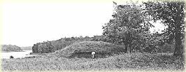
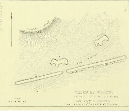
Rainy Lake, Ont.
Rainy Lake Mounds
Discovered in 1957, these mounds are just east of Fort Frances, Ontario. The Rainy River area also contains numerous mounds.
La Verendrye built a fort in this area. He most likely came down the Ottawa and French river systems into Lake Superior from Montreal following the traditional route of the later North West Company. Could the Norse have also used this route?
Geographical location: 48.720, -93.213
PF 3 (PF 5)
******
Madison, Illinois
Iron forge
The Indiana Republican Banner reported this discovery in 1835.
Geographical location: 38.716,-90.214
PF 3
April 15
Entering into the Ohio Valley we encounter not only a large number of mounds but we encounter iron ingots, metal objects, stone roads and mooring Stones. The cultures of the area also built extensive defensive fortifications, enclosures, cities and ceremonial sites.
Unlike further west, European habitation came much sooner with surveys being done as early as the 1780s. James Foster, a Newspaper editor, was making reports by 1810 and Caleb Atwater put out a book called Archaeological Americana in 1819; but by far one of the most comprehensive is Ancient Monuments of the Mississippi Valley by E. G. Squier and E. Davis. Not only do they detail their own survey work but that of several others with dozens of woodcuts and maps. This book was published by the Smithsonian in 1848 and I have used it extensively for the Central section of North America in our search for Vikings.
******
On my wish list is:
The Graves of the Golden Bear: Ancient Fortresses and Monuments of the Ohio Valley by Rick Osmon. It is a large, expensive reference that examines and maps over 45 sites and makes no bones about the relation of these sites to old world cultures. I have yet to read this one. Anyone have a good, economical second hand one around?
******
Here is some further information that I think is important about the upcoming Central section:
In 1846 it was estimated that there were over 10,000 mounds and 1000 to 1500 enclosures in this area. Many of these enclosures have been considered as defensive fortifications and all those have independent water sources.
There are numerous types of mounds. Most seem to be grave mounds, usually having a single burial at the bottom. (Squier reports many of these skeletons crumbling to dust with extreme age when exhumed.) In numerous cases later more contemporary burials are interred higher up in the mound.
Related to this are altar mounds which are many times included in burials. These would be burnt offerings but animal and human bones are also reported. They could be cremations, either done on the site or brought from somewhere else. Some contain large quantities of offerings such as one at Mound City that contained 200 effigy pipes.
Not to be confused with pipes is effigy mounds, of which I am including a few interesting examples. These seem to rarely have anything in them and are constructed in the form of geometric, human and animal shapes. Much like the Nazca lines, they are viewed best from height.
But what we are looking for are iron forges. While Foster, Atwater and Mallery pinpoint these with slag and ore, Squier uses the argument that they are watchtowers. Forges give the indication of Alban (Irish Celts) and Nordic influence.
******
* I had to go back a bit on these first two.
Gasconade, Missouri
Stone foundations 1823
Reported by Dr. Beck in his Beck's Gazeteer of Missouri. This appeared to be the ruins of a town with numerous buildings having stone foundations.The remains of the stone walls were sod covered.
Geographical location: 38.669,-91.560
PF 3
******
Louisiana, Missouri
Stone Building Remains 1846
Reported by Squier and Davis in 1848. The building was of unhewn stone with the walls 2' to 5' in height. It was guessed wood was used to complete the building. It measured 22' x 56' and contained several chambers.
These fall within the dimensions of a Viking longhouse.
Geographical location: 39.448,-91.051
PF 3
******
Cahokia, Illinois
Defensive Fortifications
The Mississippian Culture, as examined previously, linked a vast trade network along the Mississippi River including the Ohio Valley west of the Allegheneys. This predominantly peaceful society is known for it's trade, mound building and agricultural growing of crops. Several city centers were scattered across this area.
One of the major city centers of the Mississippian Culture was Cahokia. The site is situated less than five miles east of St. Louis, Missouri and is well preserved.
This constantly growing city had a population of 20,000 by CE 1250. Some experts even claim the population grew to 40,000. It was larger than London, England during the time of its existence.
Archaeologists have determined that prior to CE 1100 there was a raid of an outlying settlement of Cahokia that was along the Mississippi River, a couple miles west of the city. There is evidence that this small community was burnt to the ground and some of its residents massacred. It is after this date that construction of wooden palisades occur at Cahokia and a population surge takes place. For the next 200 years their defensive fortifications were modified and improved. Taking place in four stages, watch posts begin in a round shape, then change to square towers.
The extensive trade network and mound building of these people disappeared around 1600 with European contact, their demise coming from the migration of eastern tribes and very likely smallpox.
We can make a couple considerations from this.
Not all Norse were good guys and it is possible that some took their Vikingr to the Mississippi, raiding settlements for loot and slaves. The continuing modification of the Cahokia defensive fortifications indicate this raiding to be an ongoing issue. As well, a large number of defensive works show up east of the Mississippi with the Fort Ancient Culture around CE 1000.
It is also possible that other Norse allies may have assisted or advised in improvement of defenses. With the large number of forts present in the area we could be looking at the start of a familial or feudal style of warfare.
Geographical location: 38.655,-90.062
PF 3
May 15
A YouTube video by cf-apps7865 takes a very good look at Celtic Forts in Ireland. I believe it is important to be aware of these as we progress deeper into the Ohio Valley.
******
Scott, Arkansas
Fortifications 1894
This fortified enclosure is at present the most southern of our subjects. It was originally known as the Toltec Mounds because of its similarity to those in Mesoamerica but they are actually part of the Fort Ancient (or related) Culture. Just southeast of Little Rock they were first noted by Palmer in 1894.
This site is currently preserved as the Plum Bayou Mounds Archaeological State Park.
Geographical location: 34.645, -92.059
PF 3
******
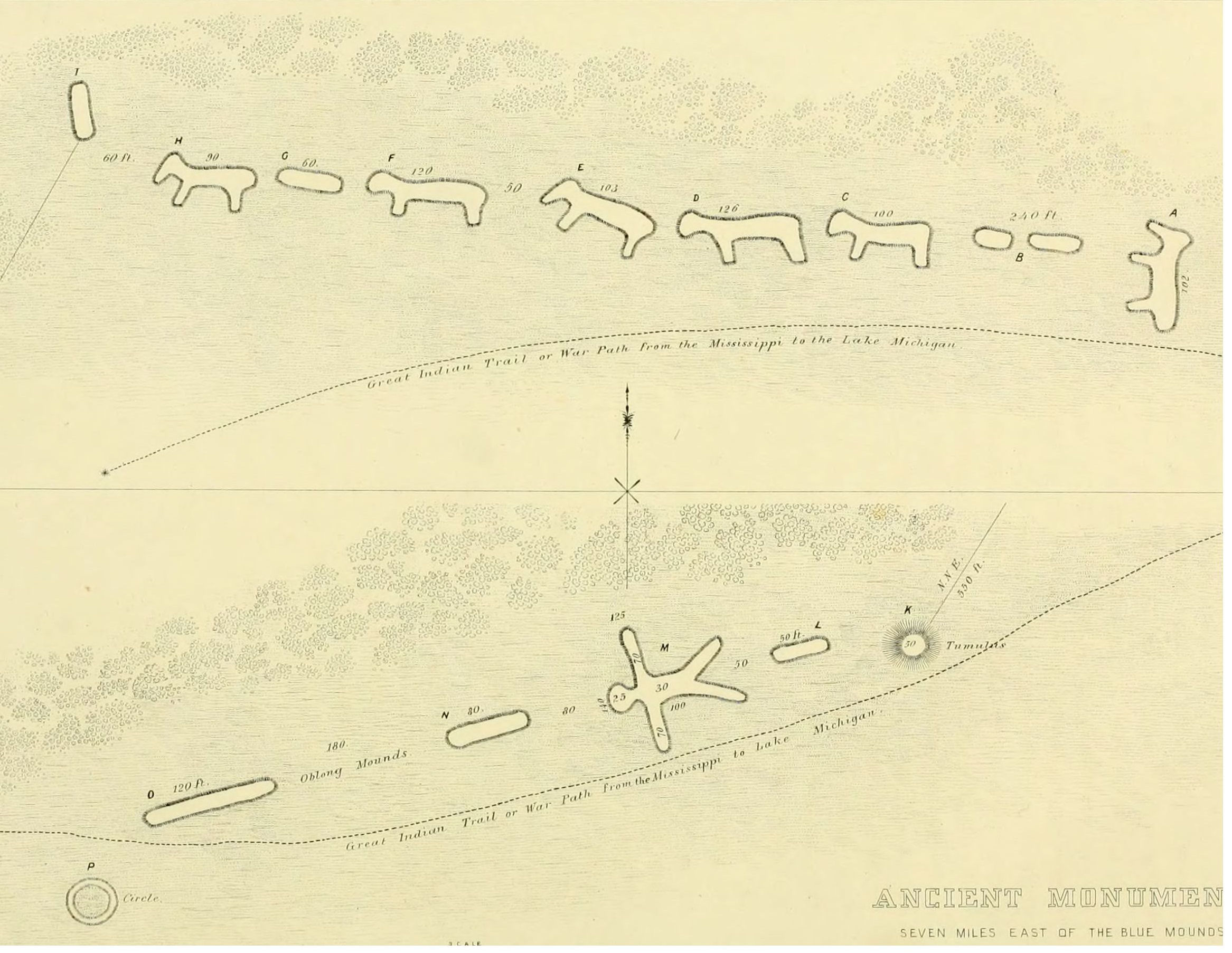
Mt. Horeb, Wisconsin
Animal Effigy Mounds 1850
There was a very large number of effigy mounds in the area roughly bordered by Madison, Milwaukee and Rockford although few exist today. They portrayed a wide variety of mammals, birds and reptiles. There were mounds that visualized human and even geometric figures.
The effigy mounds here portray animals that cannot be readily identified. They could be female deer or may be likened to horses. Nearby is a human and some geometric mounds. They were originally documented by R. C. Taylor prior to 1850.
I have done my best to pinpoint their location although this may not be correct. They no longer exist.
Geographical location: 43.022, -89.643
PF 3
******
Riley, Wisconsin
Animal Effigy Mounds 1850
These appear to be more female deer or horses. Again, this is an estimated location. They were originally documented by R. C. Taylor prior to 1850.
Geographical location: 43.015, -89.603
PF 3
******
Sainte Marie, IL
Breastplate 1819
A breastplate made up of 6 inscribed brass plates held together by iron wire was reported by Atwater in 1819. The mound this came out of is still visible by Google satellite. North 1700th Street runs through it.
Geographical location: 38.902,-88.0583
PF 3
******
Duck River, Tennessee
Fortifications
An old stone fort is said to be Celtic. It was there before settlers came to the area. The walls are of unhewn stone and a number of the mounds present are rectangular. Since initially identified Duck River has changed its course a number of times and whether these fortifications still exist or not is in question.
Geographical location: 35.460, -86.353
PF 3
******
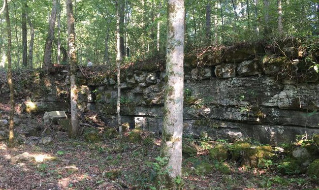
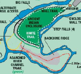
Manchester, Tennessee
Fortifications 1819
These fortifications first reported in 1819 are composed of gigantic walls that are 15 feet at base. A tree growing out of the top of the structure was cut down and displayed 357 rings, indicating abandonment of this site well before 1460.
Generally Norse and Celtic building techniques constructed walls that were much less massive. These huge walls, which are quite common worldwide,are now thought to be Pre Ice Age Megalithic Structures. However, differences in the patterns of stone indicate this site was occupied by later cultures.
This area is now known as the Old Stone Fort Archaeological Park.
Geographical location: 35.486, -86.102
PF 3
June 15
Although there will be a large number of hill fortifications covered in the next few months, many of which are just plain rock walls, their relationship to the Norse will be seen as we progress.
******
Allen County, Kentucky
Fortifications
This stonework was located on the bluffs above a sharp bend of one of the many systems in this county, possible Coruth Branch. Published in Collin's History of Kentucky. It's status today is not known.
Geographical location: 36.712, -86.019
PF 3
******
Fort Knox, Kentucky
Fortifications
This hill fort is situated on the bluffs above a sharp bend of Rolling Fork. Published in Collin's History of Kentucky. The site appears to be intact on Google satellite.
Geographical location: 37.890, -85.820
PF 3
******
Jeffersonville, Ohio
Human Remains
This area is currently preserved as the Falls of the Ohio State Park. It was also known as Kentucky Falls because of its location.
Delaware and Cherokee oral legends tell of a great battle that was fought here that involved white men from the north that built forts. They were also said to have brought with them 'strange new things'. Could this be iron and forges? A subsequent investigation of Sandy Island at the base of the falls by Col. James Moore did indeed turn up human bones. Some reports say these remains were butchered which would verify either cannibalism or a battle site.
Here is an excellent, single page article that provides a good idea of what happened here with special regards to the native perspective:
Kentucky Geneology Website - Earliest Inhabitants
Geographical location: 38.272, -85.762
PF 3
******
Louisville, Kentucky
Fortifications
Just across the Ohio River is Cherokee Park and a section known as the Big Rock.
This park was originally created during early twentieth century integration attempts for 'colored people'. Since those times the park has been extensively landscaped, however, much of the stonework here bears examination. Could this have been a demolished fortress and related to the above battle?
Geographical location: 38.233,-85.683
PF 2-3
******
Miami Township, Ohio
Fortifications
This site is near the mouth of the Greater Miami River where it intersects the Ohio River and the Kentucky border. It has been mostly populated but some remains are still visible by satellite. Geo located by topography.
Geographical location: 39.154, -84.775
PF 3
******
Oxford, Ohio
Fortifications 1832
These fortifications are at a distinct bend of Four Mile Creek. They were surveyed by J. McBride in 1832. They are currently covered by overgrowth.
Geographical location: 39.487, -84.703
PF 3
******
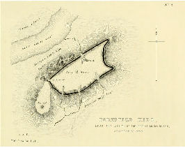
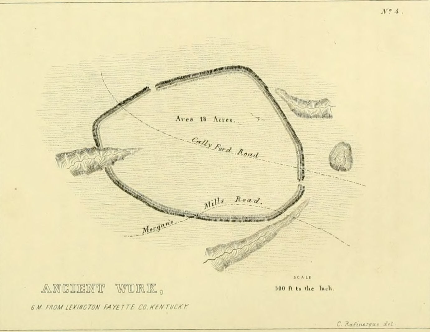
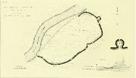
Midway, Kentucky
Fortifications
These stoneworks were surveyed by C. S. Rafinesque in 1820, our only clue is they are six miles from Lexington. This site appears to have been obliterated.
Geographical location: 38.161, -84.690
PF 3
******
Cincinnati, Ohio
Glass Beads
There are several reports of glass beads being found in local pre contact sites.
Geographical location: 39.136,-84.680
PF 2
******
Ross, Ohio
Fortifications 1840
Surveyed by McBride and Erwin in 1840 these are now covered in residential with a martini lounge overlooking what was once a large mound. Geo located by topography.
Geographical location: 39.305, -84.649
PF 3
******
Lexington, Kentucky
Fortifications 1820
These stoneworks were surveyed by C. S. Rafinesque in 1820, our only clue is they are half a mile south of the Elkhorn River (Creek). This site is not located.
Geographical location: 38.068, -84.635
PF 3
******
Here are a few more interesting links. Thanks again Tom:
Rebuilding the Sutton Hoo Ship
July 15
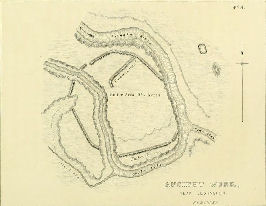
Coleraine, Ohio
Fortifications 1840
These fortifications were on a hill overlooking a wide portion of the Miami River Valley. They were surveyed by McBride in 1840. This is now residential area. Unfortunately the hill has heavily eroded.
Geographical location: 39.298, -84.634
PF 3
******
Coleraine, Ohio
Fortifications 1836
These works were surveyed by McBride and Erwin in 1836. They are now replaced with residential and roads.
Geographical location: 39.308, -84.631
PF 3
******
Lexington, Kentucky
Fortifications 1818
These stone walls were surveyed by C. S. Rafinesque in 1818. Some remnants can still be seen by geo locating.
Geographical location: 38.112, -84.629
PF 3
******
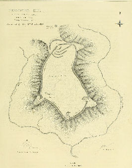
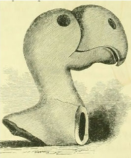
Hamilton, Ohio
Fortifications 1836
Pottery Fragment
This hill fort was surveyed by McBride in 1836. It is on the west bank of the Miami River across from the Miami University. It is preserved as the Pyramid Hill Sculpture Park.
A broken handle from a pottery jug found at this site bears the likeness of a toucan or flamingo. It's accuracy indicates the creator must have physically seen the bird and therefore the artist or the piece itself must have traveled a great distance.
Although not specifically Norse, this artifact does indicate the extent of trade in PCE America.
Geographical location: 39.372, -84.579
PF 3
******
Hamilton, Ohio
Fortifications 1836
These fortifications overlooked Seven Mile Creek. They were surveyed by McBride and Erwin in 1836. They are now residential. Geo located by topography.
Geographical location: 39.463, -84.549
PF 3
******
Williamsdale, Ohio
Stone Foundations
Near Cotton Run Creek. Cut stone foundations were found underneath one of the many mounds in the area that were obliterated for farmland.
Geographical location: 39.456, -84.539
PF 2
August 15
*There were some corrections made to the above illustrations for Miami Township, Ohio and Midway, Kentucky.
******
West Alexandria, Ohio
Fortifications 1846
This site was surveyed in 1846 by J. McBride. It can be geo located by using a topographical map as there is an unmistakable 'chip' in the heights. The site is presently cultivated fields and wooded area.
Geographical location: 39.715, -84.522
PF 3
******
Fairfield Township, Ohio
Fortifications 1840
This site was surveyed in 1840 by McBride. It appears to remain in natural condition. Geo located by topography.
Geographical location: 39.420, -84.492
PF 3
******
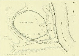
Piqua, Ohio
Stone Carving
Identified by Moorehead, Landsverk, Carlson. It is purported to be of celtic or mediterranean style.No further information is available at this time.
Geographical location: 40.149,-84.276
PF 2
******
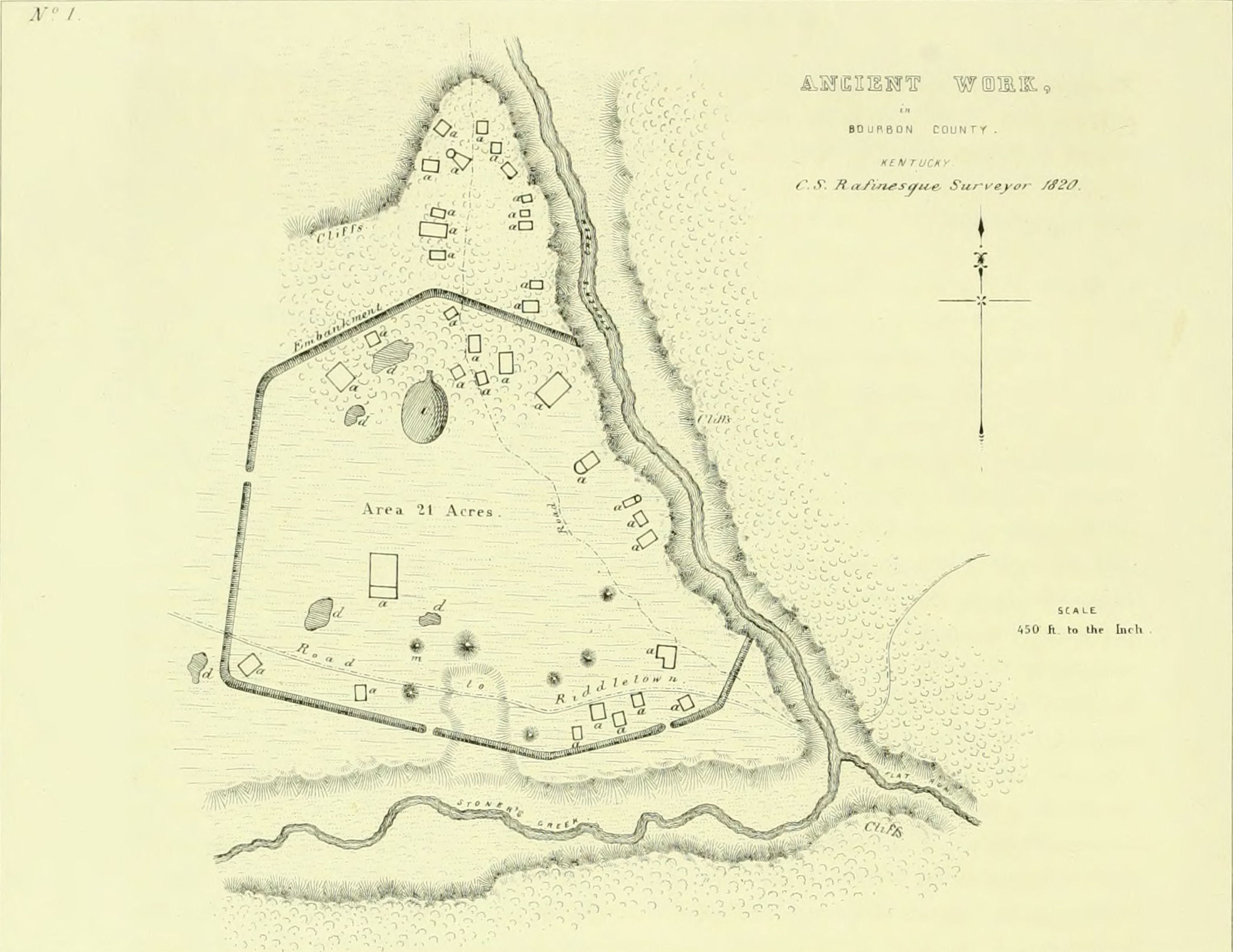
Stoners Creek, Kentucky
Fortifications 1820
At the mouth of Flat Run, this site was mapped by C. S. Rafinesque in 1820. Geo locating shows the walls have been destroyed but mounds are still present.
Geographical location: 38.289, -84.263
PF 3
******
Piqua, Ohio
Fortifications 1846
North of Piqua on the Great Miami River, this fortification was surveyed by McBride in 1846. This appears to be developed over with a dam, cemetery, Indian agency and dog park.
Geographical location: 40.178, -84.260
PF 3
******
Dayton, Ohio
Fortifications 1846
Surveyed by McBride and Forber in 1846, this was originally 3 miles below Dayton and now completely within the city limits. This appears to be completely obliterated by residential.
Geographical location: 39.678, -84.239
PF 3
******
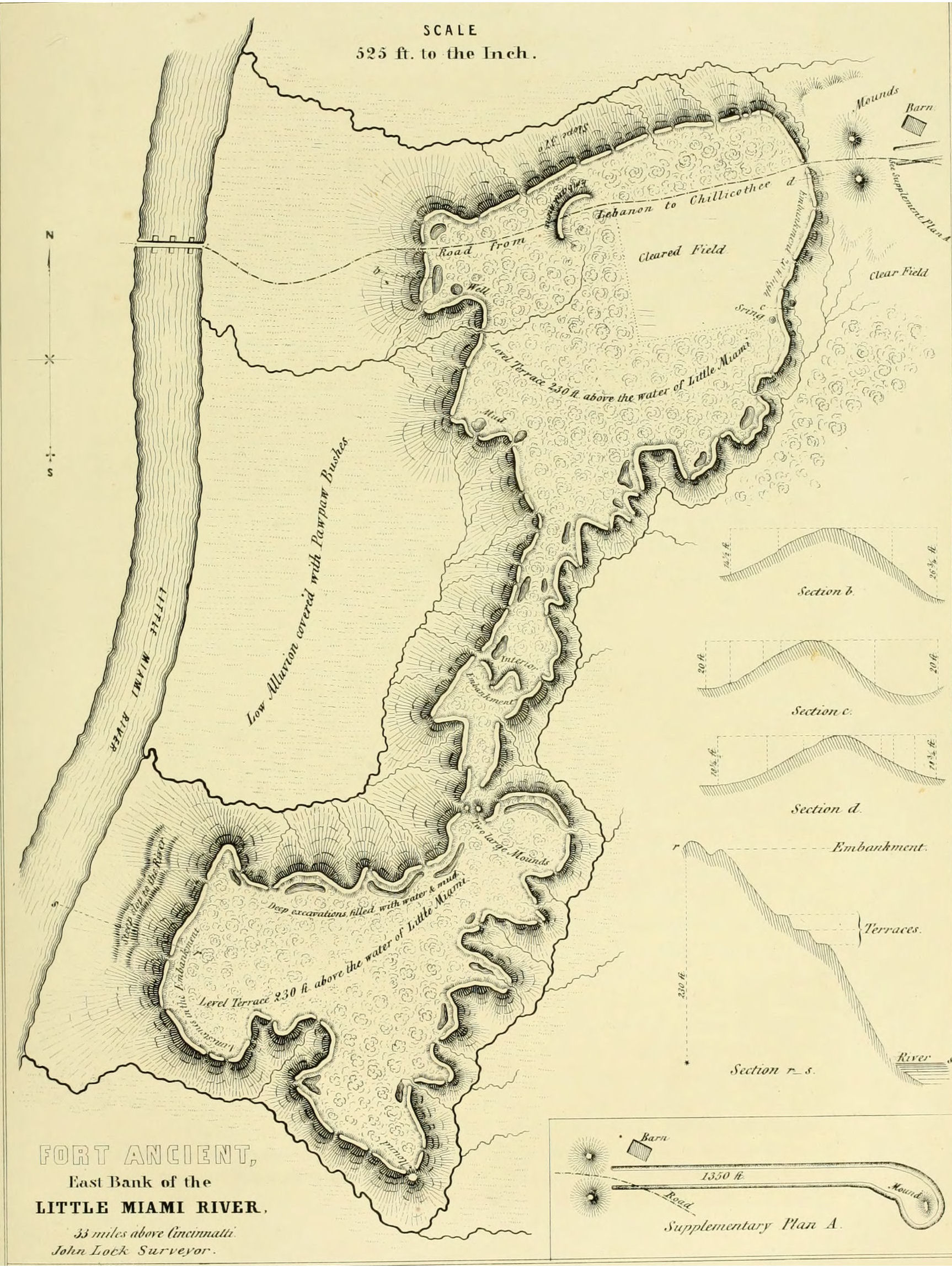
Washington Township, Ohio
Fortifications 1809
Wool Winder 1994
The Fort Ancient stoneworks are some of the best known in Ohio with just under 4 miles of walls. Surveyed and mapped by Professor Locke prior to 1809. It is a well preserved site today.
PF 3
In 1994 Joseph reports a wool winder was excavated here that is similar to a specimen in Oslo, Norway.
PF 3
Geographical location: 39.406, -84.089
September 15
Goose Creek, Kentucky
Ogam inscription
Reports of this ancient Celtic writing have come out of Clay County. No further information is available.
Geographical location: 37.115,-83.838
PF 2-3
******
Cedarville, Ohio
Fortifications
This site on the south side of Massie Creek was surveyed by Oweins and Dill before 1846. It is now preserved as the Pollock Works Ancient Hopewell Indian Village.
Geographical location: 39.740, -83.822
PF 3
******
Sautee Nacoochee, Georgia
Stone Building Remains
One mile east of the Nacoochee Indian Mound on the north bank of the Chatahoochee River can still be seen by topography the remains of a stone building. The site is quite overgrown and most of the stones taken by farmers over the years. It is covered nicely in a YouTube video by cf-apps7865.
Situated on a hilltop and having the remains of stone fortifications this could have been a small fort or an outpost. It is on a watershed system that runs south into the Chatahoochee River while less than five miles north east is the Savannah River system which leads into the Atlantic Ocean.
Upriver, the sources lead into the divide where waterways flow into the Ohio Valley.
Geographical location: 34.682, -83.683
PF 3
******
Rossford, Ohio
Fortifications
This site is unlikely to have survived the ravages of river and man.
Geographical location: 41.591, -83.587
PF 2-3
******
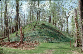
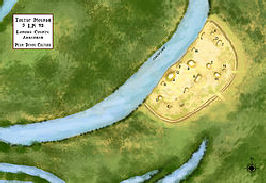
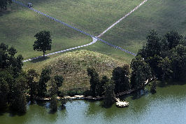
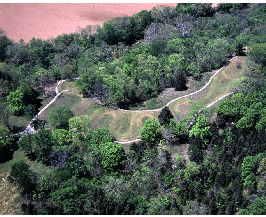
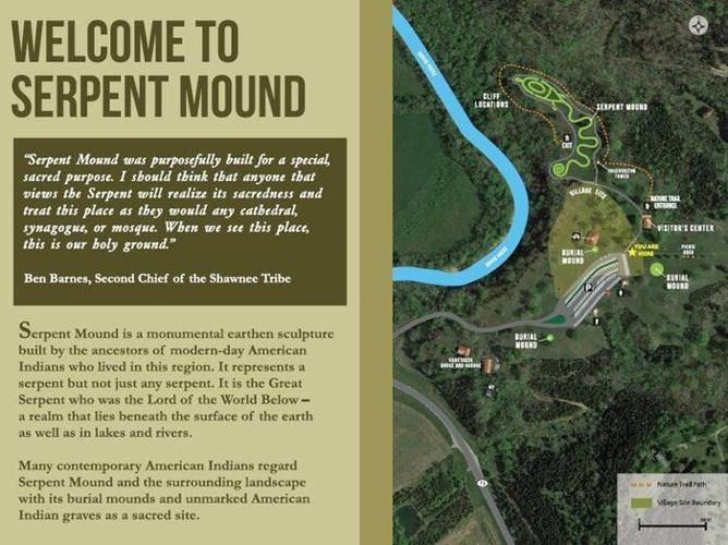
Bratton Township, Adams County, Ohio
Animal Effigy Mound 1846
One of the most reknowned of the animal effigy mounds and one we briefly looked at previously is the Ohio Serpent Mound. First catalogued in 1846 by Squier and Davis, this site has been likened to Celtic mounds in Abury, England.
The mound is believed to have been built by the Adena around 300-100 BCE and rebuilt around CE 1100 by the Fort Ancient Culture.
It is currently well preserved as the Serpent Mound State Memorial.
Geographical location: 39.025,-83.432
PF 3
******
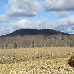
Lincolnville, Ohio
Fortifications 1838
This is now known as the Fort Hill Earthworks. Locke first described them in 1838, Squier and Davis surveyed them in 1846.
A ring count of a large tree on top of the fortifications indicated they were abandoned before CE 1200. Authors suggest they were built around CE 800.
These fortifications can be clearly geo located by topography and are now a well preserved site.
Geographical location: 39.116, -83.402
PF 3
******
Vinland Vignette
Although I am unable to provide the source to this submitted article, it nevertheless provides some excellent information about sea levels and the Greenland ice sheet.
The increasing mass of the Greenland ice sheet caused local sea level to rise more than 3 metres after Vikings colonised Greenland, flooding many settlements and contributing to their abandonment of the place.
The sea level around Greenland rose more than 3.3 metres from AD 1000 to 1450, contributing to the woes of Viking settlers and to their eventual abandonment of the island, researchers have found.
In AD 985, Erik the Red established a colony in Greenland after being exiled from Iceland. At the time, the North Atlantic region was unusually warm � the so-called medieval warm period � but after a massive volcanic eruption in Indonesia in 1257, conditions became much colder for several centuries, a period known as the little ice age.
That led to the expansion of the Greenland ice sheet, say Marisa Borreggine at Harvard University and their colleagues, causing the land adjacent to the ice sheet to subside because of the increased weight. The bigger ice sheet also had a greater mass and so exerted a stronger gravitational pull on the waters around Greenland. These two factors had roughly equal effects on sea level there.
The growth of the Greenland ice sheet reduced global sea level by 7 millimetres during this time as it locked away water, but due to other factors, there was a small overall rise on average across the world. All of this contributed to the 3.3-metre rise around Greenland.
It was already known that the sea rose in Greenland when Vikings lived there, but Borreggine�s team is the first to calculate the effect. The findings show that the coast would have retreated hundreds of metres, with the water swamping more than 200 square kilometres of land and impinging on many farms and homes.That must have had a major impact on the settlers.
"There is evidence that their diet shifted from land-based to sea-based", says Borreggine.
The settlers � including Erik the Red�s son Leif Erikson, who sailed to North America some 500 years before Christopher Columbus � were also grappling with colder weather making farming more difficult, conflict with Inuit peoples and reduced demand for walrus ivory as more elephant ivory reached Europe. By around 1450, all the settlements were abandoned.
�What we found is that sea level rise did indeed play a role in the Viking abandonment,� says Borreggine. �But it was not necessarily the number one cause.�
Greenland�s ice sheet is now shrinking fast. Local sea level is already falling around Greenland as the gravity effect weakens and the reduced weight of ice allows land to rise. If the entire ice sheet there melts, as may soon become inevitable, local sea level will fall by more than 100 metres over coming centuries� but rise globally by around 6 metres on average.
October 15
Austin, Ohio
Forge 1949
South of Austin, along Paint Creek, Arlington Mallery excavated a mound that contained three iron forges. They were built upon concrete or cobbled floors and used traditional flues. He stated these forges used bog iron, although none was present. Mallery claimed these to be Norse.
The site can be geo located by topography. This could also have been a fortification.
Geographical location: 39.427, -83.220
PF 3-4
******
Franklin, Ohio
Forge 1949
Human Remains
On the west end of Franklin, on Bray's Hill overlooking Paint Creek is the Allyn Mound which was documented in the 1840s. It is here that Mallery discovered a beehive kiln variety of smelting furnace similar to the furnaces common in ancient Peru. Rather than bog iron this type of forge uses powdered ore to create iron.
Nearby Mallery found four piles of skeletons in layers 4 to 5 feet deep.
The mound is clearly visible on Google satellite and street view.
Geographical location: 39.404, -83.186
PF 3-4
******
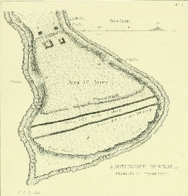
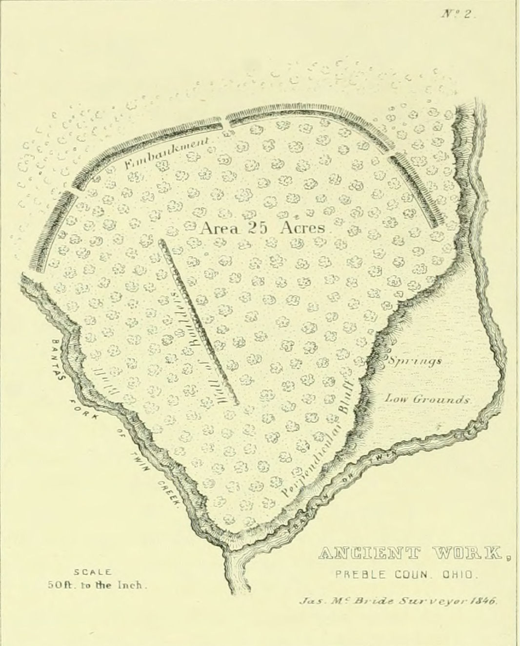
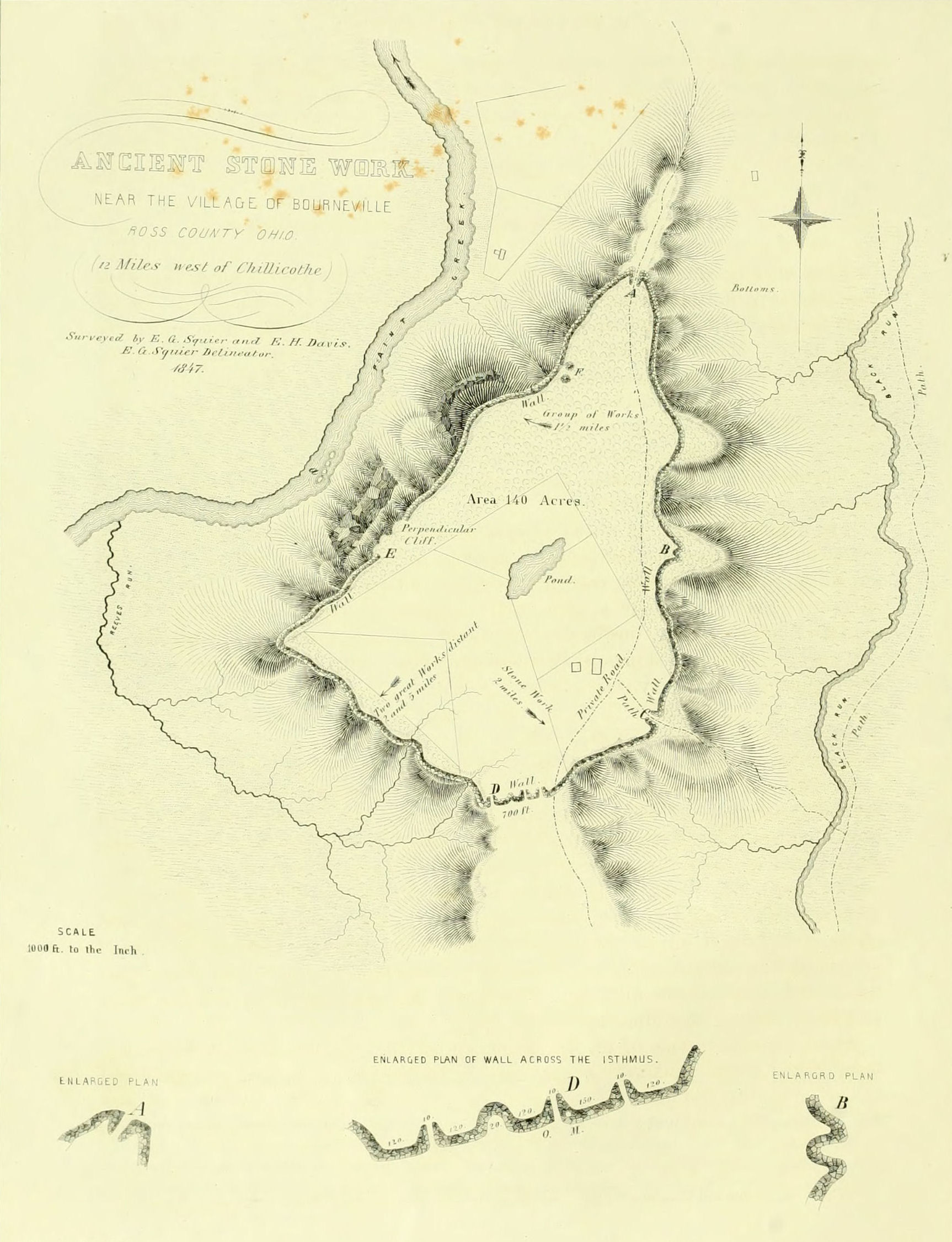
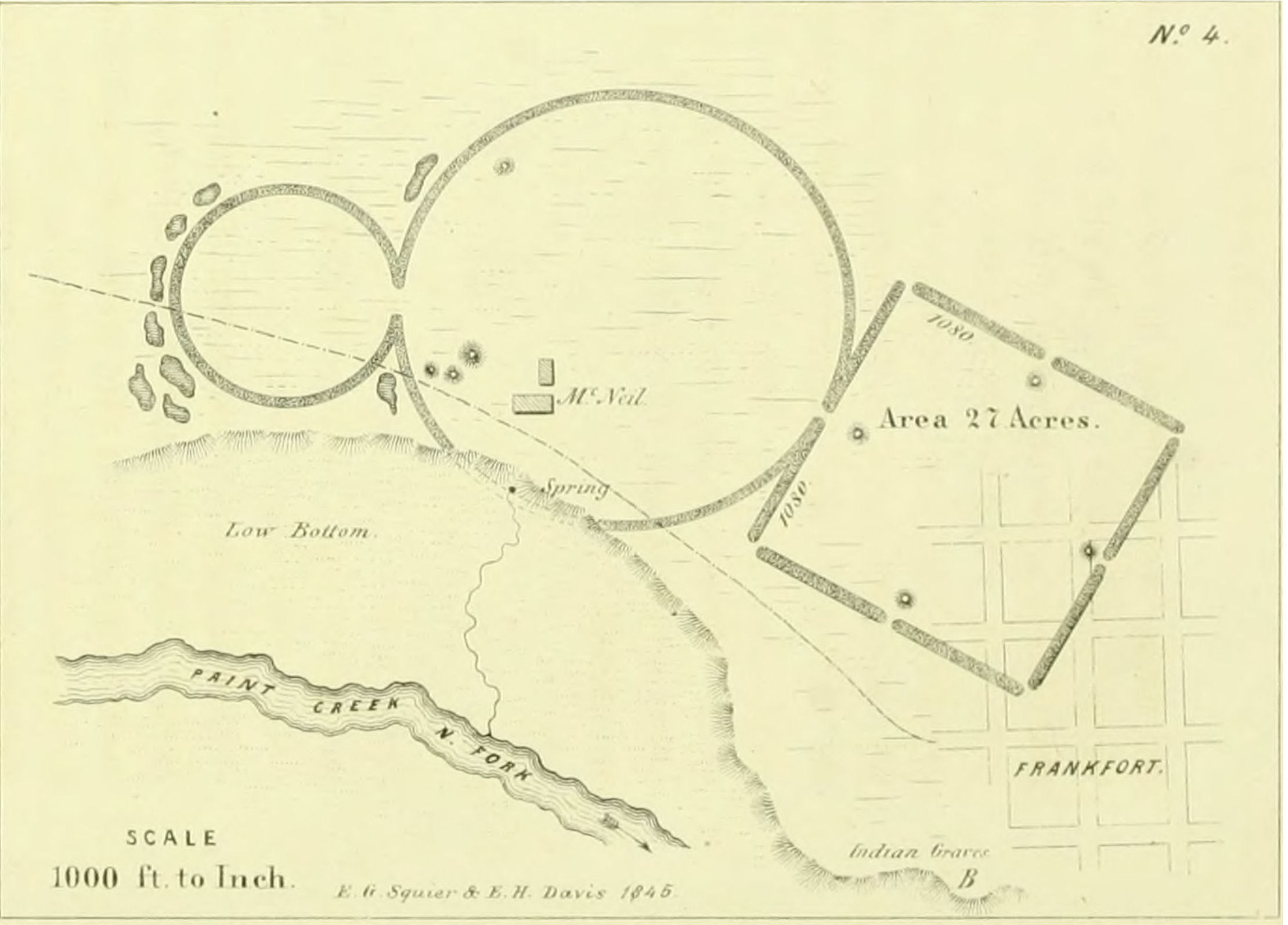
Bourneville, Ohio
Fortifications 1811
Forge 1811
copper tools 1947
iron slag ca 1947
Human Remains ca 1947
runic inscription ca 1947
Just east of Bourneville is the Spruce Hill Earthworks, one of the more controversial of the ancient sites. It was reported that to the southwest of this site there was discovered a city made up of streets in regular squares with houses having stone foundations and cellars.
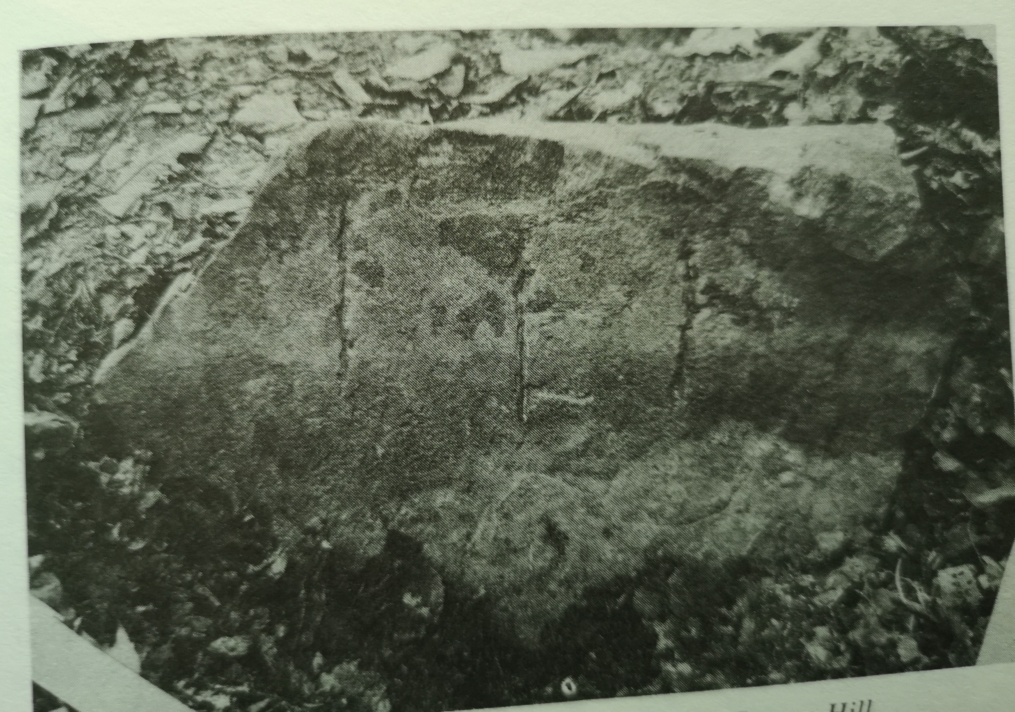
With walls estimated to be originally 12 to 15 feet high and 4 to 5 feet thick, this fortress was first reported by Foster in 1811 who identified 30 forges among the stoneworks. Nine years later, when Atwater viewed the site he agreed with Foster's assessment. It was later surveyed by Squier and Davis in 1847 who stated "Nothing is more certain than that powerful fires have been maintained for considerable periods, at numerous prominent points on the hill; for what purposes, unless as alarm signals, it is impossible to conjecture." and later said, "The suggestion that these are the traces of ancient furnaces is not to be entertained for an instant."
But according to Mallery, these are indeed ancient iron forges. He detailed his work here in his book Lost America and The Rediscovery of Lost America. His analysis and digging (yes, digging) at the site in the late 1940s turned up a number of Norse forges,a Nordic type hearth pit and 10 stone covered graves. He identified the furnaces as Nordic type although further digging revealed Celtic style furnaces at earlier levels.
Also turned up were a number of copper tools and iron slag from bog iron.
One of the graves was excavated. Mallery claimed a stone at the entrance to what he called a 'Viking' grave had runic letters on it. From the photograph, markings can indeed be seen on the stone but whether they are runic or not is in question.
What happened to the grave is unknown but I suspect Mallery reburied it. The location of the tools and slag is currently unknown but is most likely part of the Mallery collection. There are iron bars at the Fayette County Historical Museum in Washington Courthouse. This area is now well preserved as the Spruce Hill Earthworks.
Geographical location: 39.278, -83.136
PF 4
******
Worthington, Ohio
Fortifications 1850
Reported by Charles Whittlesey in 1850 from earlier surveys, it is on the right bank of the Scioto River and now occupied by the Leatherlips Cemetery. This site can be geolocated by topography.
Geographical location: 40.140, -83.117
PF 3
******
Anderson, Ohio
Fortifications 1845
Surveyed in 1845 by Squier and Davis. This site is preserved as the Hopewell Mound Group.
Geographical location: 39.361, -83.091
PF 3
******
Worthington, Ohio
Fortifications pre 1850
This site was reported by Charles Whittlesey in 1850 from earlier surveys. The fortifications are now preserved as the Highbank Park Earthworks.
Geographical location: 40.138, -83.035
PF 3
******
I am once again posting the link to Squier and Davis' survey as it is quite a critical reference to this part of the blog. It can be viewed online or downloaded as a PDF file. Although many of the sites are posted in the photo section here, there are many more illustrated in their survey and this work can be used to compare with geographical locations:
Ancient Monuments of the Mississippi Valley
November 15
Seal Township, Ohio
Unknown Structure 1847
A mile north of what was once a very typical settlement of the native people that occupied this area was a stone structure compared to some discovered in Scandinavia. It was surveyed by Squier and Davis in 1847. The native ruins appear to be obliterated by agriculture but this structure may still be around.
Geographical location: 39.078, -83.031
PF 3
******
The following article, although mainly applicable to the Allyn mound, must also be considered as we look at all the Deer Creek Valley sites.
Additional Research in Deer Creek Valley
This article details some testing that took place with the forges in Deer Creek Valley. Carbon dating of charcoal and testing of firewall glaze (a relatively new procedure) came up with dates ranging from 1550 to 1750.
Although definitely putting into question the age of the forges in Deer Creek Valley, some of the results were inconclusive and rather than providing definite answers, opens this issue to further questions.
Could testing be compromised by previous digs? Was this taken into consideration? At what strata was the charcoal taken from? Were samples taken from various strata? Is it possible these forges were used over a longer period of time than suggested?
******
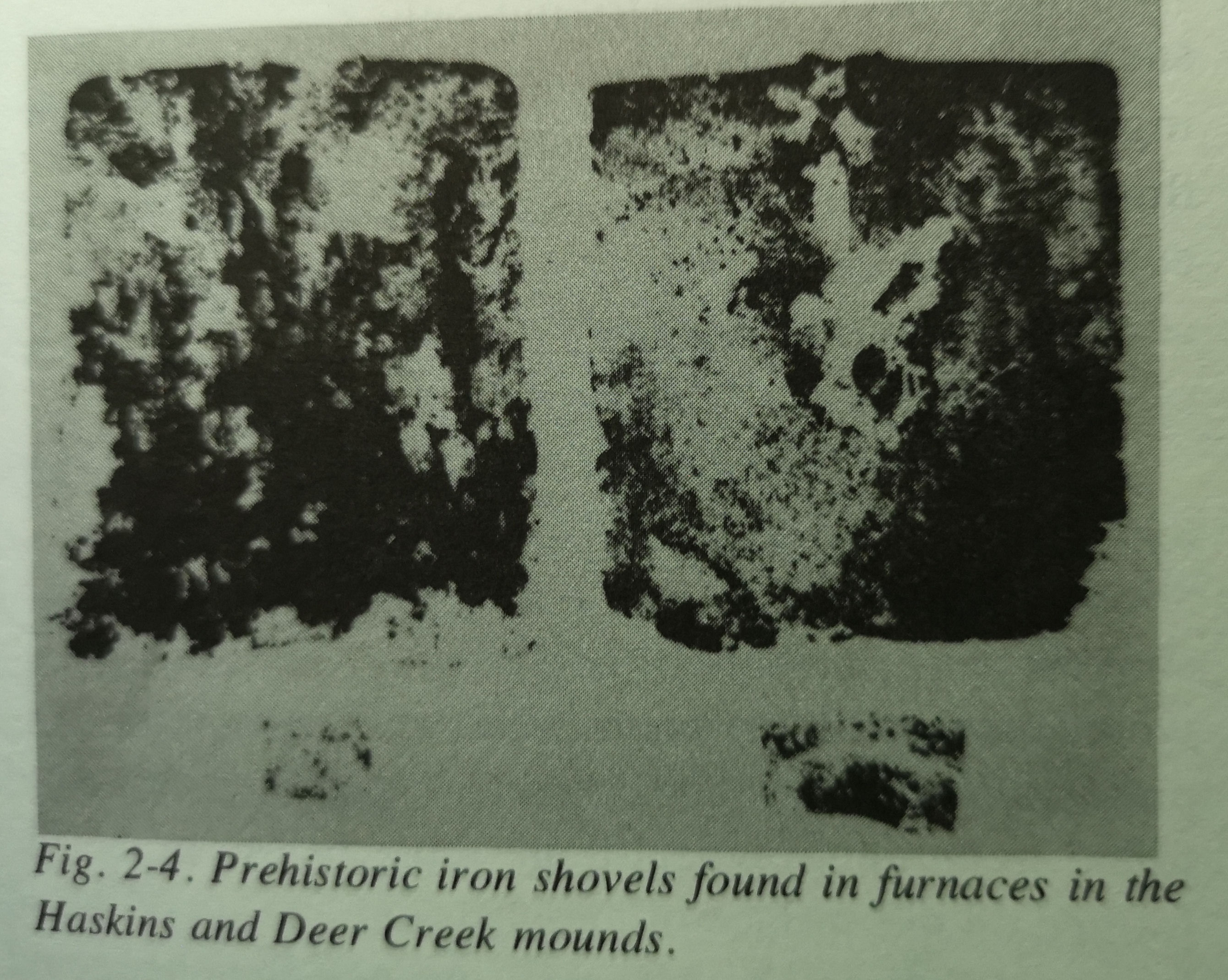
Union Township
Forge 1949
Shovel
This was part of a series of excavations Mallery did in the Deer Creek Valley that turned up 14 furnaces in total. This Norse style forge was found on the bank of the creek. Also found here was an iron shovel.
Deer Creek is about eight miles north of Bourneville.
Geographical location: 39.461, -83.026
PF 2-3
******
Union Township, Ohio
Forge 1949
Iron Bars
Shovel
Axe
On a ridge above Deer Creek, Mallery did some excavations in 1949 on a site known as Haskins Mound. He discovered four forges here.
At the base of the mound was a burial on a concrete floor that had a layer of protective boards over it. As part of this complex were found four forges, each digressing the others from Nordic to Early Celtic. The iron bar and the shovel were found within the ashes of a furnace while the axe was part of the burial.
In 1971, Keeler and Kelley, at Haskins Mound #2 found slag and a 42 pound moulded bar of iron bearing approximately six roughly made letters, CONA??. This bar is in the Fayette County Historical Society Museum, along with other specimens found by Keeler and Kelley.
Charcoal from inside the furnace gave an uncalibrated radiocarbon date of CE 1640 +-90 but inconsistencies may have made these results inconclusive.
The remains of this mound can be located by topography.
Geographical location: 39.451, -83.021
PF 2-3
******
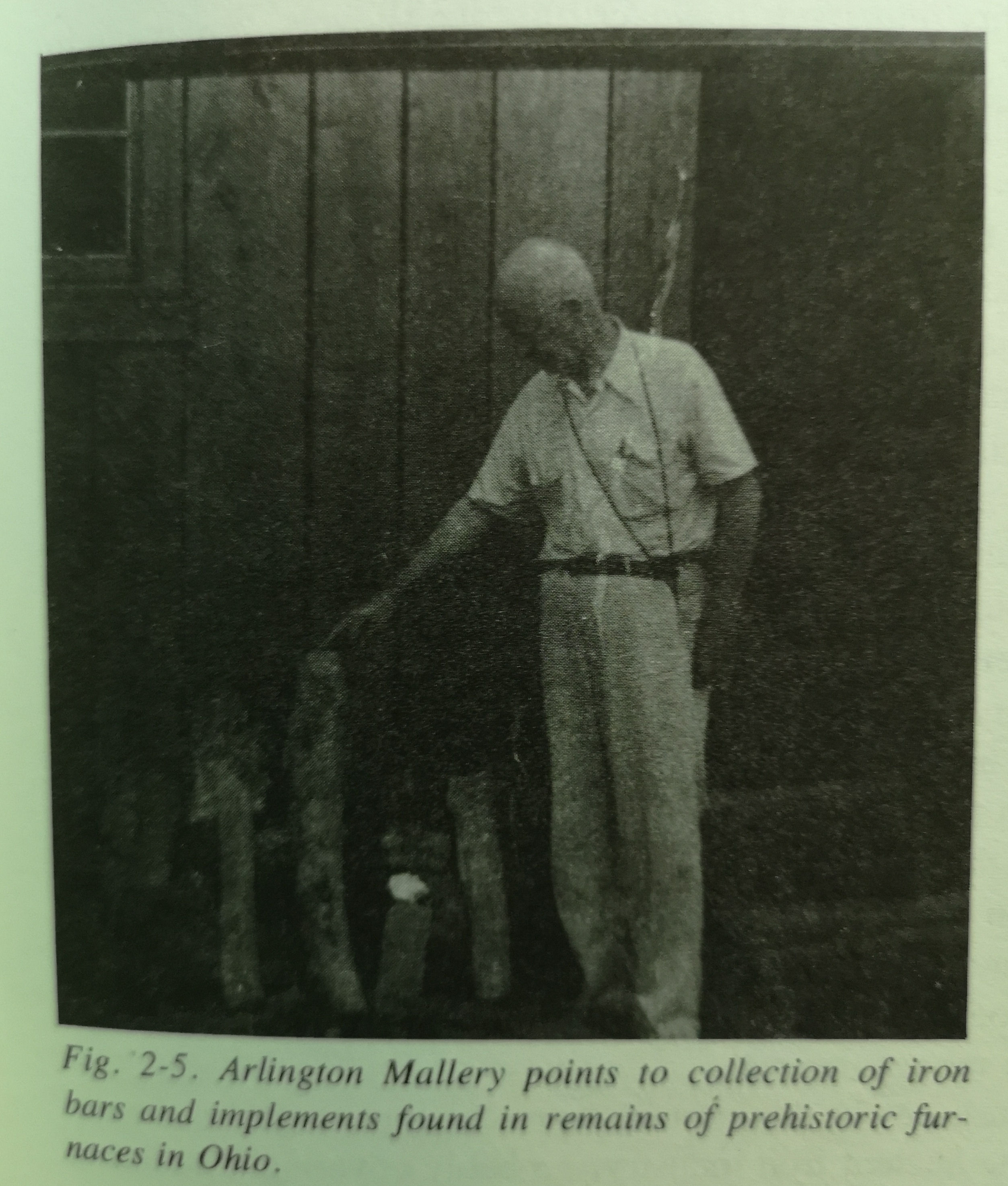
Union Township, Ohio
Forge 1946
Iron Bar
Near the head of the Deer Creek Valley, not far from the Scioto River is the Arledge or Allyn Mound. It is 100 yards downriver from the mound on the bank that was looked at previously.
This was part of a series of excavations that Mallery did in the Deer Creek Valley that turned up 14 furnaces in total. The remains of this mound can be located by topography.
Thermoluminescence dating in the 1970s came up with a 1740+-30 date.
We previously posted a photograph of Mallery holding an iron bar (reposted). This is where it was obtained by him. The bar was apparently created as a result of spillage from the furnace and was blocking the flue and thus causing its abandonment. This 62-pound piece of iron is in the collections of the Fayette County Historical Museum in Washington Courthouse.
Geographical location: 39.463, -83.017
PF 2
December 15
Chillicothe,Ohio
Early Christian Graves 1845
This is a grouping of native mounds situated on Paint Creek. It was originally surveyed by Squier and Davis in 1845. Upon excavating one of the mounds, it was found that it had been opened and 3 skeletons had been buried at a 7' depth over top of its original inhabitants. All 3 were buried with their heads to the east in early Norse Christian style. This site is now protected as the Junction Earthworks Preserve.
Geographical location: 39.319, -83.022
PF 3
******
Circleville, Ohio
Fortifications 1846
Axe or Human Figurine 1846
This site was surveyed in 1846 by P. N. White. The site now appears to be agricultural.
An unusually shaped item discovered here is made of lead and weighs half a pound. It is in the figure of an axe head or stylized human shape and was found 2' deep in a trench in these ancient works. It was fully encrusted with caliche (lead patina). Being lead it would be entirely impractical as a functioning axe so it could possibly be for ceremonial use.
Geographical location: 39.531, -83.014
PF 3
******
May I extend my wishes for a Happy Yule to all the Old Norse souls amongst us and a wonderful holiday season to everyone. Another year passes and a new one arrives. Blessings.
On January 15, 2024 I will be releasing Blood Moon Riseth digitally, book number two in the Kingbreaker Series. Book number one, No Quarter is currently available. If you are interested in a complimentary copy of this swords and sabers series, please send your request with email address to kelwionz@gmail.com
Any blog or business related correspondence can be emailed to tvcmerchant @gmail.com
....to be continued.